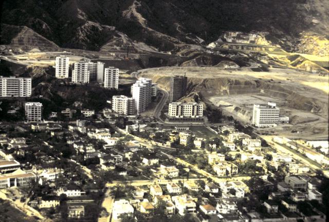
Aerial view of Kowloon Tong showing the area north of Cornwall Street. Ede Road is the road that goes uphill showing government quarters and housing schemes. HSBC's Luso Apartments (Bank flats) are further up on Warwick Road. The military quarters on Pilgrim's Way can be seen on the far left whilst Baptist Hospital established in 1963 can be viewed on the far right. Broadcast Drive is still barren. The road extension from Waterloo Road to the Lion Rock Tunnel (1967) has yet to be connected.
Source: This image came from Flickr, see https://flickr.com/photo.gne?id=35087644552
Date picture taken
1964
Gallery
Shows place(s)
Comments
also a good view of individual houses
in the Dorset Crescent, Devon Road, Somerset Road & York Road area. Thanks Moddsey for posting this photo.
Building in Cornwall Street park
Any idea what the long, low building is that seemingly sits in the middle of the park on Cornwall St, just behind Dorset Crescent? Since the 1934 planning map of Kowloon Tong marks this area as a park, could it have been a recreational building of some kind? It appears to be located in much the same spot as the current (very basic) building, which I think is just a glorified toilet block. In the photo above, the rest of the park looks to be undeveloped.
Cheers, Liz
1956 Kowloon Map
If one views the 1956 Kowloon map that is available here , the low rise building in the park does not appear to have been built. Used to reside in the area. As far as I can recall, the building was used as a place of shelter for residents and park users, similar in function as of today.