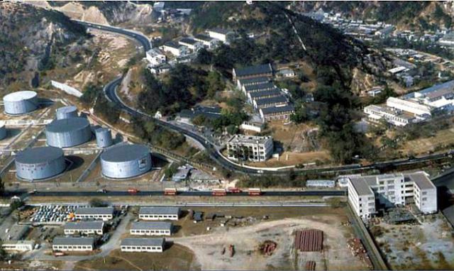
From Flickr: Upper(older) part of double image. Showing Mobil Oil Tank Farm and Lai Chi Kok Hospital.Date unknown, should be early to mid 1960's.
Date picture taken
1963
Gallery
Shows place(s)
From Flickr: Upper(older) part of double image. Showing Mobil Oil Tank Farm and Lai Chi Kok Hospital.Date unknown, should be early to mid 1960's.
Comments
Large white building at centre of photo
Does anyone know what the substantial three-storey white building was, roughly in the middle of this photo just above Castle Peak Road? Would this have been part of the original Lai Chi Kok hospital buildings?
Lai Chi Kok Hospital
Greetings, and Hi Liz. This may help - the 1956 map indicates that the buildings on this hillside were part of the hospital.
But there is a small doubt. On this map, the orientation of the buildings appear not to match well relative to the oil storage tank. The alignment of Castle Peak Road is not as precise as in the photo or in the 1952 map. So I wonder if the label includes the three-storey building. Regards, Peter
1956 map - https://gwulo.com/taxonomy/term/478/places-map#16/22.3359/114.1398/Map_…
1952 map - https://gwulo.com/jubilee-buildings?a=1#16/22.3379/114.1419/Map_by_ESRI…
Doctors' Quarters
Hello Peter, thanks for your info. I was also initially confused by the differences in the photos. I've just been reading the 2017 research study (here: http://www.jtia.hk/wp-content/uploads/2017/07/lw_paper_eng_120.pdf), which contains a site map on page 59, clearly identifying the building in question. According to the accompanying text, it appears to have been the Doctors' Quarters for the hospital. It was apparently demolished in 1968 when Castle Peak Rd underwent alterations.
Re: Doctors' Quarters
Hi Liz and Peter,
there is a lower part of the photo that is posted separately. It is from about 1976, and still shows the building in question (I think so).
Regards, Klaus
Doctors' Quarters
Hi Klaus, thanks for the extra photo. it certainly looks like the building was still there when it was taken. Can the photo definitely be dated to 1976 rather than the late 1960s? If so, the demolition date given in the research paper (1968) must be incorrect. Cheers, Liz
Edit: I've now found an identical photo to yours, also in the 2017 research report (on page 54), which I had missed when skimming through earlier. It's dated 1975 and the source is cited as the Government Records Service. I'll see if I can find some more information to confirm when Castle Peak Rd was realigned.