Thank you. When i follow the link i see another reference to "scans" - but my question is how to find the scans? I would like to see the other sections of the map if possible please.
D'Oh! Sorry, was looking for a separate collection based on the publication. Now can see it's all there mixed in with relevant photos, thanks.
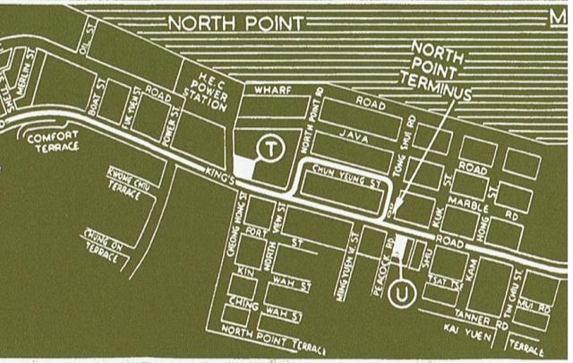
It's a beaut map but very stylised and I'd caution readers not to rely on it's accuracy. For instance, the distance from Power Street to North Point Rd is actually twice as far as that from North Point Rd to the tram terminus; North Point road between the two points is far from straight; and the overall orientation of that section of Kings Rd from WNW to ESE is completely wrong. Understand that this doesn't ereally matter cionsidering thwe purpose of the map, but it threw me out! Cheers.
Comments
map source
Hello Moddsey, could you please upload a link to the source map of the detail shown here? I'm interested in seeing the key.
Also, the map itself seems out of scale and distorted. Fascinated to see the full thing if possible pleaase.
S.
Re: Map
I am afraid the scans are as is. An explanation is given here
scans?
Thank you. When i follow the link i see another reference to "scans" - but my question is how to find the scans? I would like to see the other sections of the map if possible please.
Re: Scanned Images
At the top right of the page, there is a clickable area to navigate the gallery of the map of the tramlines. Please see if you are able to do so.
D'Oh! Sorry, was looking for
D'Oh! Sorry, was looking for a separate collection based on the publication. Now can see it's all there mixed in with relevant photos, thanks.
It's a beaut map but very stylised and I'd caution readers not to rely on it's accuracy. For instance, the distance from Power Street to North Point Rd is actually twice as far as that from North Point Rd to the tram terminus; North Point road between the two points is far from straight; and the overall orientation of that section of Kings Rd from WNW to ESE is completely wrong. Understand that this doesn't ereally matter cionsidering thwe purpose of the map, but it threw me out! Cheers.