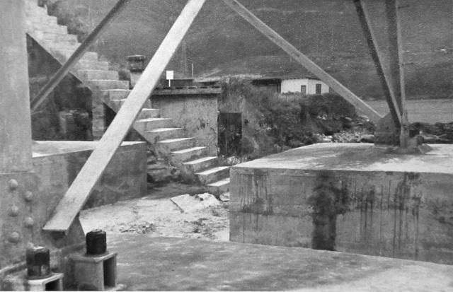
The building with the chimney and open door just beyond the steps was, I understand, where the generator for the British war-time Lyon Light was housed. The Lyon Light itself was higher up on the ridge and its building is visible on at least one more of my photographs. The building is still up there in the dense vegetation and can just be made out as a grey rectangle on Google Earth. Behind this hut can be seen the shelter for our firing range. It stood on the small promontory where pill box 37 stood before being washed down onto the shingle beach by Typhoon Gloria in September 1957. One of these large concrete bases now lies beneath the promenade just inside the end of the new sea wall.
Date picture taken
1958
Gallery
Shows place(s)
Comments
PB 37 & Lyon Light.
Hi Andrew,
Thanks for putting so many of your photos on gwulo for us to enjoy. You and your mates obviously had a great posting in HK.
Locating the remaining coastal pillboxes and their Lyon Light shelters is a hobby of mine. Sad I know, but there we are. Having previously searched for PB 37 and its LL shelter unsuccessfully, I was interested to read your comments, elsewhere on the PB's demise, and above that the LL shelter is visible in another of your pics and is still there today. However, I've gone through all the other photos you've posted without being able to spot anything looking like a typical LL shelter. Which photo is it in please? Alternatively, would you mind telling me how to find it? Just can't wait to get the anorak on again!
Hi,
Hi,
If you look towards the end of my set, you will find a colour photograph, 'Little Sa Wan from the Cape Collinson Road' - the one that has a blue coloured ship heading out to sea across the mouth of the bay, you should be able to make out a small single storey building on the skyline of the ridge. On the photograph it looks as though one of the aerial masts seems to be pointing up towards it. I tried to reach this building some time around 2004 by way of a steep flight of newish concrete steps that left the road/path and led up the left hand side of the high bank that was being re-inforced with concrete. The roof of the building on the ridge line slightly below me was visible but the vegetation was so dense I gave up. I then tried to get to the building from the path to the lighthouse but the same applied. I suspect that it's even worse now! I believe that this Lyon Light was positioned on the roof and suspect that there is nothing to see in the building. You'll need more protection than your anorak!
Happy hunting!
Andrew
Thanks Andrew
Thanks for the swift reply. Much obliged for the info. I'll have a wander and let you know the result.
I forgot to mention that the
I forgot to mention that the building is just visible as a faint grey rectangle on Google Earth.
Andrew
Generator Room for Collinson Anti-Aircraft Searchlight
Hi Andrew,
I finally got around to visiting the building you mention up on the ridge a few days ago and posted the pics at www.gwulo.com/node/30794. Rob quickly identified it as the shelter for the Collinson Anti-Aircraft Battery Searchlight and crew. Additionally he mentioned that the room in which the searchlight electricity generator was housed was down at the point. Considered with what you say about the building in the photo above, I guess its one and the same that you and Rob are talking about.
Thanks for the photos and information.
Fantastic!
Fantastic!
Your fear about snakes and other creepy crawlies is clearly not as great as mine was. Mind you, on my solitary wanderings on the hills during my short HK holidays in the early 2000s nobody knew where I was, and I didn't have a mobile phone, so I was always a bit cautious about going into dense undergworth or onto really rocky terrain. With hindsight I should have left my likely(?) itinerary with the hotel Reception staff.
Your photographs are really interesting. The building is much larger than I thought it would be but maybe the clue is in your new title 'anti-aircraft searchlight'. I had previously thought that the light and the large generator building down on the shoreline at the Point were basically tied in with PB37. However, buildings of that size some distance away from PB37 would not be typical of a PB and Lyon Light installation. So, it's just as likely that the bigger installation on the ridge at Little Sai Wan might also have been connected with the coastal battery on the small headland where the Cape Collinson Correctional Complex now stands further round the coast towards Big Wave Bay. A clue might be in another of my photographs and subsequent contributions showing the 'cave' at the place where the road/now path leading down to Little Sai Wan is closest to the ridge line. There was (and still is?) a sort of narrow box section structure above head height there.. I recall that in 1958 I saw the name Dorman and Long (British steel company) on its then metal work. One contributor has described this as a conduit for a water pipe or something similar. As I know from seeing clean water spewing out of a broken water main on the other side of the road in 1987, its unlikely that the one over the 'cave' was also carrying water - much more likely to have been telephone or whatever cables leading up to the Cape Collinson road and thence the battery at Cape Collinson. Perhaps, somebody might be able to determine what, if anything, is in that small 'bridge'.
Somewhere, I have read that when the Japanese were landing in the Lyemun area they took a dislike to this light at Little Sai Wan and shelled it as well as PB37. It is recorded in David Banham's excellent book (Not the Slightest Chance p126) that Lt Scantlebury just managed to escape from PB37 'much cut about by wire'. I suspect that without the protection of PB37, the men, including Flt Lt 'Dolly' Gray, who were manning the small wireless station at Little Sai Wan also withdrew to Stanley. Old maps do not show a road down to Little Sai Wan from the Cape Collinson road until it was either put in by the Japanese or more likely by the British when the large camp at Little Sai Wan was being built in late 1949 or early 1950. So, it seems likely to me that Scantlebury and Gray and their men would have followed the small path that connected the Cape Collinson lighthouse to Chai Wan. They must have been relieved that, as they probably passed the East Brigade headquarters at Tytam Gap, the Japanese advance was being made up and over Mt Parker.
In my 1957/8 folder there is a photograph titled something like 'Group at the Point' that might be of interest. I tried to insert it but lost all this so have had to start again! Perhaps David can do that for me? http://gwulo.com/atom/22225 In the foreground there is a row of several small square concrete blocks at least one still having the very rusty remains of a metal upright in it. I well remember that in 1958 they led down to what was a very short concrete 'jetty' - no need for a long one as the water was deep there. It struck me years later that when PB37, the searchlight shelter, its generator building and also the small wireless station were being built and in use, the easiest way to get to them would be by sea with those rusty remains being the landing place. Similarly, I suspect that the mid air concrete staircase leading up the hillside to a zig zag path on my monochrome photograph that shows the old generator building and I believe heads this part of the correspondence might well date from 1940 or whatever. I don't think that it was to do with the R.A.F. Little Sai Wan that I knew as it led nowhere relevant to that camp. Seventeen years would not have been long for a concrete 'staircase' to survive. Of course, much of this is conjecture, but it seems to have some merit, so I'd welcome any further exploration and thoughts. Sorry I just dare not risk inserting the photographs into this rather lengthy piece! Andrew
Photos
Hi Andrew, instead of inserting the photos in the text, an easier alternative is just to paste a link to the relevant photo.
Regards, David
Thanks David.
Thanks David.
With the help of a software savvy son, I've done that at the appropriate place. I hope that I can do it again if and when necessary! The zig zag concrete path that used to climb up the ridge from the top of the concrete staircase, meeting the camp road at its lowesr(?) bend, is clearly visible on one of the 1945 dated aerial photographs held by the Lands Department. Some years ago I bought several from the North Point office and can recommend them and the Lands Department helpful staff to anyone looking for really high quality images of much of HK taken by the R.A.F in 1945 and 1949, some from 10,000ft and others from 20,000ft but the resolution is excellent. Similarly, the Lands Department published a great book some time around 2006 which contains fascinating aerial photographs from about 1960(?). I don't know whether it is still on sale or whether further editions covering different decades have been published. Andrew
"Bridge"
Hi Andrew,
Referring to the question in Para.2 of your post of 23-2-2016 above on the function of the "bridge" over the cutting, it was me who said it was a water channel at www.gwulo.com/atom/22207.
Here's a view of it from above.
I don't really know what it was for and just guessed it was for water from its general appearance.
Also, I hadn't realized that a "place" had previously been made for the cutting/former cave at www.gwulo.com/node/28598. Now that I've found it, I've attached the appropriate "place" ref to the relevant pics. Cheers.
Hi GW
Hi GW
Yes - that definitely looks like a water channel and I don't think that it is the structure that I remember from 1958 - unless it has a metal girder on its bottom surface bearing the name 'Dorman and Long' and perhaps 'Middlesborough'. I cannot understand why a water channel would run down what was essentialy the crest of the long ridge. Perhaps it would have been the easiest route for fresh water to be led down from one of the catchwaters just above the Cape Collinson road and down to both the AAA site, its generator house down at the Point and also the small pre-war wireless station, all of which would require potable fresh water. This route is especially likely if it was built before the 'camp' road, as I'll always call it, was put in. I have long felt that this road was built some time after both the searchlight system and the wireless station were built - it probably being much easier to transport building materials, equipment and the staff to run them by sea from either Kai Tak or Central. Similarly, the original(?) manned lighthouse at Cape Collinson would have been very difficult to build from the landward direction. Marked on pre WWII maps the only land access to its site was by a small path leading from Chai Wan and around the bottom of the Little Sai Wan Bay (where R.A.F. Little Sai Wan camp was built in 1950) and then along what I always call the lighthouse path. When the Japanese dug out the cave the water channel was obviously capable of being self supporting in the cave's roof and would also have fed any installations that they had at Little Sai Wan. It could have even been used to supply water to the lighthouse. I remember early in 1958 scrambling up form the Cape Collinson road, roughly above where the camp road jopined it and walking along a huge catchwater towards Chai Wan. It was bone dry and it was very big, the top of it being well above my head and I am 6ft tall and it was just as wide. Goodness knows where all the water it would take was going! I cannot believe that it was built just to keep the water from getting onto the Cape Collinson Road, so maybe it went right round by Tytam Gap and helped fill the Tai Tam Tuk reservoir. Another mystery! I think that all that area is now covered with cemeteries so the catchwater has probably disappeared. There was a small stream that ran down the hillside on the Chai Wan side of our camp but, prior to the camp being built, it would have passed through a small farm and would almost certainly have been polluted by the time it reached the sea. In 1958 our amahs washed all our clothes in that stream. Some of the above is speculation but I have some faith in it being correct. Happy hunting, Andrew.
Hi GW
Hi GW
Thanks for adding your recent photographs to the Place map. They give anyone visiting the cutting/cave an excellent insight into exactly what we have been discussing. Yes, I have always believed that of the many R.A.F. postings, anywhere in the world during the 1950s, I and my pals got the best - modern living accommodation, fantastic swimming 'just round the corner' off the Point, so much of the still exotic orient to explore, better pay than we'd have had in England and compared with Britain, which had 45% purchase tax on many things, amazingly low prices - although the Australians on the camp had twice the pay that we had. However, when we saw the American fleet entering the harbour past our camp, I for one stayed away from the shops because everything rocketed in price! Best wishes, Andrew
Below is a photograph taken
Below is a photograph taken in 2000 of one of these aerial bases. (Andrew S)
ERROR: No media found for mid=31679