Hi Andrew, this is my estimate of your location when this photo was taken.
Referring to the 1952 map, east of the Sek Kong Camp, Kam Tin Road (current name) runs just south of a small hamlet called Wing Ning Li. At that spot, your camera was looking north, so the green pond on the map could be the same one in the photo. The distant valley appears to match the contours in the 1952 map, and a current Google aerial photo. This stretch of the road is now full of new and used car dealers, and car repair shops. Regards, Peter
Thank you for identifying the correct location, Phil. I’m afraid that 61 years of believing that the photograph was taken in the Yuen Long area caused me to mislead Old Timer into his detailed search in that area. Sorry Peter!
With hindsight, the mountain on my photograph stands out in so much isolation, especially on the left side, that it was unlikely to have been where I had originally thought. A big problem for me when I took those photographs in 1958, and even in 1981, was that I had no maps to keep myself orientated, and the New Territories was unknown territory. All I knew was that I was somewhere along the circuit of Castle Peak Road and its extension round by Kam Tin and over to the East and probably Tai Po Market, rather than the short cut back to Kowloon over the Twisk Route - although I recently realised that my wife and I took a bus back over the Twisk in 1981,
Greetings Folks. Trying is part of the journey to success and in this case, no surprise the heavy lifters came to my rescue. Many thanks! Some spurs and valleys in Hong Kong look similar so one has to be certain of the clues. Andrew, no need to apologize, I enjoyed the search and will continue with your other photos some of them no doubt will bring us together again. Regards, Peter
Despite Kai Kung Leng (雞公嶺\圭角山) north of Kam Tin is also quite imposing, its shape generally did look similar to Castle Peak range a certain angle, without the cliffs. Throwing in the vegetation patches it would be more confused. If the peak had not been clipped when the photo was taken the identification shoudl be easier.
This photo - https://gwulo.com/atom/22163 is my present challenge. It looks like Andrew was travelling north after taking the photo of Castle Peak from Tuen Mun. By now, he was at Hung Shu Kiu still quite a distance before reaching Yuen Long. The camera would be looking to the west-northwest. One clue is this photo pin just east of Shui Fu Rd by Route #9. Testing of this link did not work for me, so the spot is a short distance east of the junction of Shui Fu Road and Yuen Long Highway.
Thank you both for all your help. I still have a feeling (probably wrongly) that this photogragh was taken at the same place as the one showing the buffalo hides being dried. The fact that the latter was a colour slide and this one was monochrome might lead you to think that they were taken on different occasions and at different places. However, I now recall that a friend lent me his camera on at least one occasion so that I could take both colour and monochrome photographs. If this was the case on the day when I photographed the buffalo hides, the river side on the monochrome picture looks very much like that on the right hand side of the buffalo hide photograph. Are the distant hills on the monochrome photograph in keeping with those vaguely to the North East of the buffalo hide photograph? I have a very open mind about these locations!
Hi Andrew, the photogragh ( https://gwulo.com/atom/22163) was probably taken from about the same place as the buffalo hides photo. The 1952 map shows a stream to the right (east) of the hides, and its orientation is similar to the one in the photo, so this indicates the camera was looking more north than northeast. The photo shows two main ridgelines, one closer to the camera and the other about three times the height in the distant. I have not been able to relate both with the contours in the 1952 map. There is a 570-metre peak directly north of the buffalo hides, perhaps it is the peak in the photo. Regards, Peter
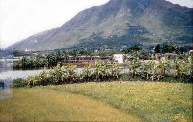
The range of hills definitely matches this colour one, which I simply named New Territories. I have possibly caused some confusion by mentioning the buffalo hide photograph, which does not show the range of distant hills either so well or maybe not at all. I still feel that this one and the monochrome one that you are currently investigating (below) and the buffalo hide one all show this same stretch of river.
Thank you Andrew, for pointing out the connections between the three photos including the buffalo hides photo. I was searching for two separate ranges to match the two ridgelines. Your explanation removed my doubt. Those houses are on fairly mild slope at the foothill which matches the 1952 map. Regards, Peter
The other images show the view towards Wang Chau area from the south east (ish). That pointy hill in the distance now has the Wang Chau service reservoir on its western slope. So this would tie in with your memories of where the buffalo hide was. i.e you were looking nw from the Kam Tin area. Phil
Memories are very tricky! I now have a recollection that the colour photograph showing the river, the fence and the banana plants was not taken in 1958 but is from 1981 when my wife and I walked along that stretch of road, and I was so pleased to recognise the spot where I took the two photographs in 1958 showing the river and the buffalo hides. I wonder why I didn't take another one aimed just to the left showing the other half of the river bend. I'm tempted to get David to move the photgraph into the 1981 gallery but it's probably better to leave it here with the above explanation.
Goodness me! I have now had a good look at my 1958 gallery and I see that there is indeed another photograph showing the left hand side of the river bend but from a spot several feet to the left of the one showing the fence and banana plants. Again, that was taken in 1981 and should really be in my 1981 gallery.
Comments
Kam Tin Road looking north - possibly
Hi Andrew, this is my estimate of your location when this photo was taken.
Referring to the 1952 map, east of the Sek Kong Camp, Kam Tin Road (current name) runs just south of a small hamlet called Wing Ning Li. At that spot, your camera was looking north, so the green pond on the map could be the same one in the photo. The distant valley appears to match the contours in the 1952 map, and a current Google aerial photo. This stretch of the road is now full of new and used car dealers, and car repair shops. Regards, Peter
Tuen Mun
This is Tuen Mun with castle peak in the background.
Hi Phil (and Old Timer)
Hi Phil (and Old Timer)
Thank you for identifying the correct location, Phil. I’m afraid that 61 years of believing that the photograph was taken in the Yuen Long area caused me to mislead Old Timer into his detailed search in that area. Sorry Peter!
With hindsight, the mountain on my photograph stands out in so much isolation, especially on the left side, that it was unlikely to have been where I had originally thought. A big problem for me when I took those photographs in 1958, and even in 1981, was that I had no maps to keep myself orientated, and the New Territories was unknown territory. All I knew was that I was somewhere along the circuit of Castle Peak Road and its extension round by Kam Tin and over to the East and probably Tai Po Market, rather than the short cut back to Kowloon over the Twisk Route - although I recently realised that my wife and I took a bus back over the Twisk in 1981,
Best wishes, Andrew
Tuen Mun
There is a similar view on one of your other pictures here: https://gwulo.com/atom/33288
Edit: it appears moddsey and I were thinking the same thing at the same time :)
Similar Mountain View
Greetings Folks. Trying is
Greetings Folks. Trying is part of the journey to success and in this case, no surprise the heavy lifters came to my rescue. Many thanks! Some spurs and valleys in Hong Kong look similar so one has to be certain of the clues. Andrew, no need to apologize, I enjoyed the search and will continue with your other photos some of them no doubt will bring us together again. Regards, Peter
Castle Peak
Hi There,
Despite Kai Kung Leng (雞公嶺\圭角山) north of Kam Tin is also quite imposing, its shape generally did look similar to Castle Peak range a certain angle, without the cliffs. Throwing in the vegetation patches it would be more confused. If the peak had not been clipped when the photo was taken the identification shoudl be easier.
T
Comparing Peaks and Valleys
Thank you tngan for the support.
This photo - https://gwulo.com/atom/22163 is my present challenge. It looks like Andrew was travelling north after taking the photo of Castle Peak from Tuen Mun. By now, he was at Hung Shu Kiu still quite a distance before reaching Yuen Long. The camera would be looking to the west-northwest. One clue is this photo pin just east of Shui Fu Rd by Route #9. Testing of this link did not work for me, so the spot is a short distance east of the junction of Shui Fu Road and Yuen Long Highway.
https://www.google.ca/maps/@22.4274133,114.0043194,3a,75y,312.05h,90.78…
Regards, Peter
Hi Peter and Thomas,
Hi Peter and Thomas,
Thank you both for all your help. I still have a feeling (probably wrongly) that this photogragh was taken at the same place as the one showing the buffalo hides being dried. The fact that the latter was a colour slide and this one was monochrome might lead you to think that they were taken on different occasions and at different places. However, I now recall that a friend lent me his camera on at least one occasion so that I could take both colour and monochrome photographs. If this was the case on the day when I photographed the buffalo hides, the river side on the monochrome picture looks very much like that on the right hand side of the buffalo hide photograph. Are the distant hills on the monochrome photograph in keeping with those vaguely to the North East of the buffalo hide photograph? I have a very open mind about these locations!
Best wishes Andrew
New Territories, possibly north of Kam Tin
Hi Andrew, the photogragh ( https://gwulo.com/atom/22163) was probably taken from about the same place as the buffalo hides photo. The 1952 map shows a stream to the right (east) of the hides, and its orientation is similar to the one in the photo, so this indicates the camera was looking more north than northeast. The photo shows two main ridgelines, one closer to the camera and the other about three times the height in the distant. I have not been able to relate both with the contours in the 1952 map. There is a 570-metre peak directly north of the buffalo hides, perhaps it is the peak in the photo. Regards, Peter
Hi Peter,
Hi Peter,
The range of hills definitely matches this colour one, which I simply named New Territories. I have possibly caused some confusion by mentioning the buffalo hide photograph, which does not show the range of distant hills either so well or maybe not at all. I still feel that this one and the monochrome one that you are currently investigating (below) and the buffalo hide one all show this same stretch of river.
Best wishes, Andrew
New Territories
Thank you Andrew, for pointing out the connections between the three photos including the buffalo hides photo. I was searching for two separate ranges to match the two ridgelines. Your explanation removed my doubt. Those houses are on fairly mild slope at the foothill which matches the 1952 map. Regards, Peter
Kam Tin
The other images show the view towards Wang Chau area from the south east (ish). That pointy hill in the distance now has the Wang Chau service reservoir on its western slope. So this would tie in with your memories of where the buffalo hide was. i.e you were looking nw from the Kam Tin area. Phil
Memories are very tricky! I
Memories are very tricky! I now have a recollection that the colour photograph showing the river, the fence and the banana plants was not taken in 1958 but is from 1981 when my wife and I walked along that stretch of road, and I was so pleased to recognise the spot where I took the two photographs in 1958 showing the river and the buffalo hides. I wonder why I didn't take another one aimed just to the left showing the other half of the river bend. I'm tempted to get David to move the photgraph into the 1981 gallery but it's probably better to leave it here with the above explanation.
Goodness me! I have now had a good look at my 1958 gallery and I see that there is indeed another photograph showing the left hand side of the river bend but from a spot several feet to the left of the one showing the fence and banana plants. Again, that was taken in 1981 and should really be in my 1981 gallery.
Andrew
Andrew