Stereo card from US Library of Congress titled:
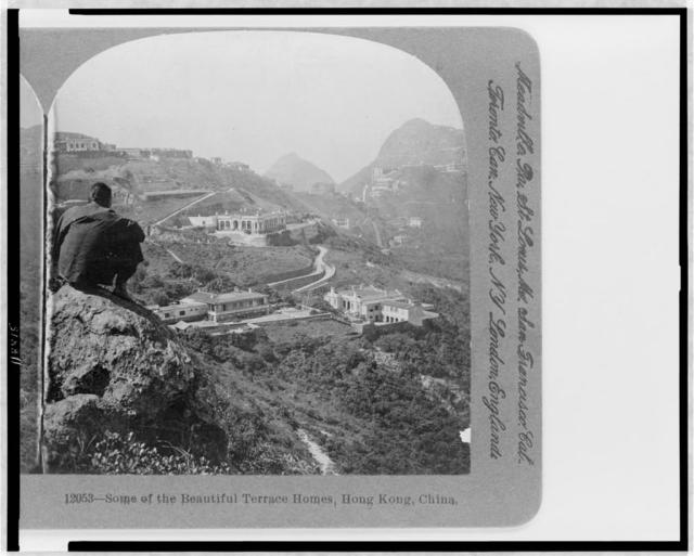
12053-Some of the Beautiful Terrace Homes, Hong Kong, China
This is looking along Barker Road back toward Victoria Peak, right, and High West, center.
Can you help identify the houses ?
Date picture taken
1910s
Gallery
Shows place(s)
Comments
Top-right I think we can see
Top-right I think we can see the ends of Mt Austin Barracks visible either side of the flat-topped hill.
Regards, David
Houses on Plantation Road
This old photo was taken from a seldom used viewpoint and consequently gives a seldom seen view of early houses on the north slopes of Mount Gough. I believe it was taken from close to the east end of Pollock's Path. Here's the view from there yesterday for comparison.
The ridge lines of Mount Gough (left), High West (center) and Victoria Peak (right) in both photos show strong similarities so I'm fairly confident that the original photographer wasn't far from here.
The buildings in the old pic can be identified by identifying what stands on the same sites today and referring to old maps. The old photo has three sizeable houses in the middle distance. A road runs down from the upper one, but splits before reaching the lower two. Referring to todays photo, the sites of the three old houses are now occupied by the following buildings;
Upper old house - The Belvedere, 51 - 61 Plantation Road, which is the brown colour developement just to the left of High West.
Lower left house - Fung Shui, 50 Plantation Road, the white, older style building below and to the left of The Belvedere.
Lower right house - Abergeldie, 52 Plantation Road, covered in scaffolding to the right of Fung Shui.
Plantation Road can't be seen in todays photo due to tree cover. In the old pic it appears as a straight line running uphill from the top of the road linking the three old houses. This link road is still there today, but is also hidden in trees in the new photo. It's the driveway from Plantation Road down to Fung Shui and Abergeldie and still splits in two before reaching them.
The Peak maps of 1909 (www.gwulo/atom/14774), 1912 (www.gwulo/atom/13074) and 1924 (www.gwulo/atom/13017 & www.gwulo/atom/13018) all show this part of Plantation Road with The Belvedere above the road, and Fung Shui and Abergeldie below, in approximately the same positions as today. However, the 1909 map has the positions of Fung Shui and Abergeldie reversed, which must be a mistake assuming they didn't swop names.
The text accompanying this photo on the US Library of Congress website dates it to 1906. I'm not aware of anything in the photo that contradicts that date.
David - much obliged if you would link the above to the "place" pages of the Belvedere, Fung Shui and Abergeldie.
I have uploaded a higher
I have uploaded a higher resolution version of this photo: