Greetings. I wonder if the camera was looking to the east from the Little Sai Wan Bay before the area was filled in. The high hill in the distance would then be Tin Hau Shan. There are several Google photos at the current Siu Sai Wan Promanade. Regards, Peter
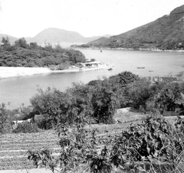
This photograph was in a group showing several pictures of Bill’s friends taken when they walked through the lower part of the village of temporary resettlement huts at Chaiwan and the camera was pointed roughly to the North. They were taking the short cut from Shaukiwan back to our camp, rather than suffering the long walk back via the Tai Tam, Shek O and Cape Collinson roads. I didn’t include all the photographs as they were rather repetitive. The wooded hill on the left is the ‘island’ in the middle of the Bay, which was connected to the main Island by a narrow strip of sand(?). I believe that hill is still there but now built on and hidden amongst tall buildings. The hills in the distance are those somewhere at the back of Junk Bay and the short stretch of road at the top right is just before the bend where one got the first sight of Little Sai Wan - that view is now hidden by tall vegetation. Several photographs in the 367;gallery show this place when seen from the Cape Collinson Road. Best wishes Andrew
Sorry, I am not certain where the Tsui Wan estate is, but here are two of the photographs taken from my 1957/8 gallery that show where the 'island' was. I think it still appears on Google Earth as a wooded hill - it certainly did into the early 2000s. By 1957/8 the reclamation had filled in more of the bay than existed on Bill's 1952/3 photograph.
Best wishes, Andrew
Chai Wan from Cape Collinson Road, by Andrew Suddaby
Chai Wan from Cape Collinson Road, by Andrew Suddaby
Andrew, many thanks. It looks as though the estate occupies what would have been the southern tip of the island and the rest of the island has since been lost under Wing Tai Road and a large open car park. Phil
Hi, There is a photograph in my 1987 gallery that shows the hill In October that year. The fly over and car park look right on Google Earth, but I wonder if part of the hill is still there beneath them and partly still covered in trees? If I can find it, I think that I might have one taken in the early 2000s - too modern to appear on Gwulo? Yes, below is the one that I was thinking of, taken in December, 2001. I'm pretty sure that the hill was still there more or less in the centre, albeit surrounded by skyscrapers. Cheers, Andrew
Chai Wan from Cape Collinson Road, by Andrew Suddaby
Chai Wan from Cape Collinson road., by Andrew Suddaby
Comments
Lamma Island
Isn't that Lamma Island in the background?
Camera location
Greetings. I wonder if the camera was looking to the east from the Little Sai Wan Bay before the area was filled in. The high hill in the distance would then be Tin Hau Shan. There are several Google photos at the current Siu Sai Wan Promanade. Regards, Peter
Hi Moddsey and Old Timer,
Hi Moddsey and Old Timer,
This photograph was in a group showing several pictures of Bill’s friends taken when they walked through the lower part of the village of temporary resettlement huts at Chaiwan and the camera was pointed roughly to the North. They were taking the short cut from Shaukiwan back to our camp, rather than suffering the long walk back via the Tai Tam, Shek O and Cape Collinson roads. I didn’t include all the photographs as they were rather repetitive. The wooded hill on the left is the ‘island’ in the middle of the Bay, which was connected to the main Island by a narrow strip of sand(?). I believe that hill is still there but now built on and hidden amongst tall buildings. The hills in the distance are those somewhere at the back of Junk Bay and the short stretch of road at the top right is just before the bend where one got the first sight of Little Sai Wan - that view is now hidden by tall vegetation. Several photographs in the 367;gallery show this place when seen from the Cape Collinson Road. Best wishes Andrew
island
I wonder if the island was where the Tsui Wan estate now stands?
Thanks Andrew
Noted the location. Just that the island does look rsther large and elongated though. Best wishes!
Hi Phil,
Hi Phil,
Sorry, I am not certain where the Tsui Wan estate is, but here are two of the photographs taken from my 1957/8 gallery that show where the 'island' was. I think it still appears on Google Earth as a wooded hill - it certainly did into the early 2000s. By 1957/8 the reclamation had filled in more of the bay than existed on Bill's 1952/3 photograph.
Best wishes, Andrew
Tsui Wan Estate
Andrew, many thanks. It looks as though the estate occupies what would have been the southern tip of the island and the rest of the island has since been lost under Wing Tai Road and a large open car park. Phil
Thanks
Thanks for the photos.
Hi, There is a photograph in
Hi, There is a photograph in my 1987 gallery that shows the hill In October that year. The fly over and car park look right on Google Earth, but I wonder if part of the hill is still there beneath them and partly still covered in trees? If I can find it, I think that I might have one taken in the early 2000s - too modern to appear on Gwulo? Yes, below is the one that I was thinking of, taken in December, 2001. I'm pretty sure that the hill was still there more or less in the centre, albeit surrounded by skyscrapers. Cheers, Andrew
Similar Scene
Similar scene to the original photo but taken at a higher elevation.