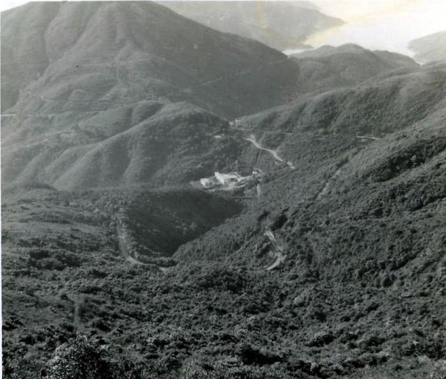
Does anyone know what the large building is in the centre of the photograhph? Might it be one of the buidings associated with the Tai Tam reservoir?
Date picture taken
1957
Gallery
Shows place(s)
Comments
Sai Wan waterworks at Tai Tam Gap
I think this is the Sai Wan waterworks. The road loop is Tai Tam Road as seen from the north. If you zoom in, is that the aquaduct spanning the gap in the middle?
Thank you Phil.
Thank you Phil.
I have been trying to locate the Sai Wan waterworks and the aquaduct on Google Earth, but without success. I don't remember ever seeing them myself. Is the stretch of water in the background Tai Tam Bay? Are you able to put pins for them on the 1952 map? Best wishes, Andrew
Tai Tam Harbour
Hi Andrew
Yes, the bay in the top of the image is Tai Tam bay/harbour. You can just make out the Red Hill Peninsula poking in to the water from the upper right of the image. By the looks of the angle I would imagine Stephen was most likely at the top of Mt Parker between where the two radar sites are today (were they installed back then?) looking south east.
I've tried to add the aquaduct (Attn david - perhaps we can fix the name of that node?) as a place here but am having problems at the moment, but you can see the place here: https://gwulo.com/node/35179. The modern day waterworks are just to the south of that point.
Cheers
Phil
re: Tai Tam Harbour
Hi Phil,
Good job on spotting the location for this one.
No need to change the Place's name in this case, see: https://en.wiktionary.org/wiki/aquaduct ;-)
Hi Phil and David,
Hi Phil and David,
Yesterday I spoke with Stephen about this photograph. From the Little Sai Wan camp he and his pals took the 'short cut' heading Westwards out of the West end of the camp. This path (which for some strange reason I never used) was a very old one appearing on early maps. It went as far as Chai Wan. From there they climbed up the relatively clear lower slope of Mt Parker until they reached a path and then a catchwater. They followed this in a southerly direction and he is pretty certain that the photograph was taken from that catchwater. I see on Google Earth that there is still a path contouring along there and suspect that it follows the catchwater - as many of the contouring paths always did.
The photograph now reveals several other interesting features. The contouring Cape Collinson Road is visible on the extreme left, and does the small white mark beyond and above the Sai Wan waterworks buildings show part of the East Brigade headquarters? The contouring Tai Tam Road continues along the Right hand side of the photograph and theShek O Road can be seen heading off trowards Tai Tam Harbour.
Once again, I am amazed that all the times we travelled along the road we never saw the waterworks building or the road leading off to it. Perhaps sitting in the back of a speeding and covered 3 ton truck, with only a restricted view out of the back, had something to do with it! Andrew
Aqueduct
Wow! Still learning after all these years. I stand corrected.
Hi Phil. No correction
Hi Phil. No correction needed. Basically you were orientated in the right place. They were certainly on Mt Parker, but lower down from the summit. Your eyes 'on the ground' are always better than mine, which are some 60 years and 7,000 miles removed! Andrew
correction
apologies Andrew, I was replying to David's earlier comment about the spelling of "aqueduct", I realise now that my comment is quite ambiguous. It wasn't my intention. Anyway, it's great to know that Stephen remembers where he was. I'm glad I was able to help jog the memory banks.
I think I am on a roll at the moment so if there are any other places that remain unidentified let me know and I will see if I can work them out before my powers disappear...:)
Without remembering which
Without remembering which ones, I believe that there must be quite a few photographs of places in the 367 Assocition gallery that lack a positive identification. The same is also possibly the case in my own 1981 and 1987 galleries. By the way, I recently spent an enjoyable afternoon going through your own blog covering film locations - an excellent piece of work. Don't forget my request that you might be able to discover which film, if any, was reputed to end with the demolition of the old R.A.F. camp at Little (Siu) Sai Wan. That must have been in very late 1997 or early 1998. Keep up the good work. Best wishes, Andrew