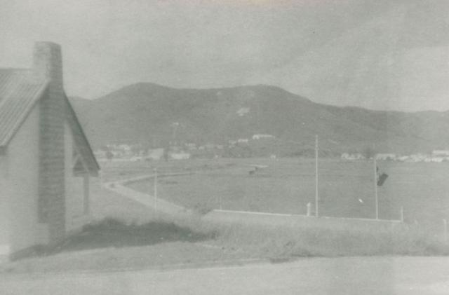
Thanks for posting John, I remember this view well. The road out of camp leads you on to the Sha Tau Kok Road.
The buildings on the far side of Sha Tau Kok Road belong to the army camp at San Wai, and on the hills behind them are the insignia of regiments (in white stone) who had been based in this area.
Thanks, Brian, I'm glad someone recalls this view. Does the road you mention still exist? (I'm trying to work out whether, next time I'm in HK, it might be worth my having a look at this area). Regards, John
The Sha Tau Kok Road is now a very busy road and the whole area appears to have changed a lot.
It looks like most of the farms and villages have gone and the whole area has changed into a giant area for junk yards.
Elain Kwan,, who has been doing a study of Queens Hill, tells me the camp has become overgrown since the police stopped using it.
It is probably still a restricted area so I don't think there would be much for you to see.
If you go into Google Maps and type in Wong Hau Shan Drive it should take you to the area and if you are on satellite view you will spot the Police Recreational area which was Queens Hill Camp.
Here is a link to a photo looking across from San Wai Camp to Queens Hill, the Sha Tau Kok Road would be about two thirds up from the bottom and Queens Hill beyond that.
It was proposed to use the site for a University a few years ago, but the Govertment changed its mind. Part of the previous camp is nowing being repurposed into public housing.
A few days ago EOD had been dispatched to a construction site in the area for some bombs. The 'Wong Hau Shan' mentioned in the news clip is Queen's Hill.
On the other hand, San Wai Camp is now being occupied by PLA.
Comments
Queens Hill Camp,Fanling
Thanks for posting John, I remember this view well. The road out of camp leads you on to the Sha Tau Kok Road.
The buildings on the far side of Sha Tau Kok Road belong to the army camp at San Wai, and on the hills behind them are the insignia of regiments (in white stone) who had been based in this area.
Thanks, Brian, I'm glad
Thanks, Brian, I'm glad someone recalls this view. Does the road you mention still exist? (I'm trying to work out whether, next time I'm in HK, it might be worth my having a look at this area). Regards, John
Queens Hill Camp
Hi John,
The Sha Tau Kok Road is now a very busy road and the whole area appears to have changed a lot.
It looks like most of the farms and villages have gone and the whole area has changed into a giant area for junk yards.
Elain Kwan,, who has been doing a study of Queens Hill, tells me the camp has become overgrown since the police stopped using it.
It is probably still a restricted area so I don't think there would be much for you to see.
If you go into Google Maps and type in Wong Hau Shan Drive it should take you to the area and if you are on satellite view you will spot the Police Recreational area which was Queens Hill Camp.
Here is a link to a photo looking across from San Wai Camp to Queens Hill, the Sha Tau Kok Road would be about two thirds up from the bottom and Queens Hill beyond that.
https://www.flickr.com/photos/47079330@N03/7703559116/in/photolist-7KcJeN-wNXymM-9g7DD6-w9EE8x-x6yhtz-cJJKJL-cFyaXG-cFvotC-cJLYhE-cFv9Hy-cEtDDG-cF4FkW-ciBEYE-cF5NsE-wZcJGY-ouoTFP-4xfwv6-x7hhEZ-oeCD7D-oeqHCf
Best regards
Brian.
Re: recent incident in the area
Hi there,
It was proposed to use the site for a University a few years ago, but the Govertment changed its mind. Part of the previous camp is nowing being repurposed into public housing.
A few days ago EOD had been dispatched to a construction site in the area for some bombs. The 'Wong Hau Shan' mentioned in the news clip is Queen's Hill.
On the other hand, San Wai Camp is now being occupied by PLA.
T
Queens Hill camp
T.
Thank you for the information.
Regards
Brian Clift.