It appeared to be so. I have not been in the area for more than a year. My memory is a bit unclear. But if Iam there I'll know.
If you still have the photo copies of the HK Island Country map I made for you a few years ago, the path route numbers on the map matched the numbers engrated onto these stone markers. Remember you spotted the 24/241 marker back then, closer to Wanchai Gap? If you were walking up from Aberdeen you wouldn't miss marker 25 next to the catch water just outside one of the BBQ areas.
If time permits we might as well form a small group to look for them and see if we could cover those known to us in a day. That would still be a pretty long hike around the hills, stretching from the eastern side of Upper Aberdeen Reservoir to the upper part of Peel rise and most of the paths/site in between.
These markers seemed to be well within the water collection network of the Aberdeen Reservoirs. I have not seen any of these in the Pokfulam or Tai Tam area.
Yes, there are many route options in the area. Some sections of some paths are not frequently being visited. Like a section of Lady Clementi's Ride from the catch water to Nam Fung Road. I have gone through it a few times and for each and every time, my exposed skin would make contact with spider webs.
Oh, now that you mentioned Peel Rise, it has quite a few number of marker stones along the slopes. Four of them, I think. One close to the top (for the foot path to the AOP under the Matilda's, one next to a pavilion where Peel Rise meets the Island Trail (the other end of path 241), and two down at the catch water.
There are still glitches like inaccurate labelling and partal coverage of some paths, but these will improve in time. I checked further and found Google had covered parts of Sai Kung together with section of the longer Trails as well. I will check out Tai Mo Shan and other area later.
Just checkd out Cheung Chau & Peng Chau and found the common paths there are covered for over 85%. The obsured ones are not probably because the camera block is towering over our heads and would need much head room to get through. Bush wacking likely not supported as of this configuration. Dispite the glitches we may find it is awesome.
Comments
Re: Marker stone
Hi David,
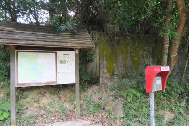
Did you spot the marker stone of the paths on its sides unique to the Aberdeen area, just a bit on the right hand side of the emergency phone?
T
Re: Marker stone
Is that what we can see in the photo to the right of the grey pole? No, sorry to say I missed that.
There is also a triangular concrete post near here. I couldn't see any markings on it to know what it was used for.
Regards, David
Re: Stone Marker
Hi David,
It appeared to be so. I have not been in the area for more than a year. My memory is a bit unclear. But if Iam there I'll know.
If you still have the photo copies of the HK Island Country map I made for you a few years ago, the path route numbers on the map matched the numbers engrated onto these stone markers. Remember you spotted the 24/241 marker back then, closer to Wanchai Gap? If you were walking up from Aberdeen you wouldn't miss marker 25 next to the catch water just outside one of the BBQ areas.
If time permits we might as well form a small group to look for them and see if we could cover those known to us in a day. That would still be a pretty long hike around the hills, stretching from the eastern side of Upper Aberdeen Reservoir to the upper part of Peel rise and most of the paths/site in between.
These markers seemed to be well within the water collection network of the Aberdeen Reservoirs. I have not seen any of these in the Pokfulam or Tai Tam area.
Thanks & Best Regards,
T
Re: Stone Marker
Yes, that'll be a good walk. I see the stones on Peel Rise most often, as that's a walk I do from time to time.
Regards, David
Re: Stone Markers
Hi David,
Yes, there are many route options in the area. Some sections of some paths are not frequently being visited. Like a section of Lady Clementi's Ride from the catch water to Nam Fung Road. I have gone through it a few times and for each and every time, my exposed skin would make contact with spider webs.
Oh, now that you mentioned Peel Rise, it has quite a few number of marker stones along the slopes. Four of them, I think. One close to the top (for the foot path to the AOP under the Matilda's, one next to a pavilion where Peel Rise meets the Island Trail (the other end of path 241), and two down at the catch water.
Thanks & Best Regards,
T
Re: This piece of rock
Hi David,
Just realized Google had made some of the Hiking Trail on the island available. I mean this piece of rock from Street View, back pack version.
T
Wow, the streetview coverage
Wow, the streetview coverage of the island trails is surprisingly complete. I haven't met the google backpack yet though!
Regards, David
Re: Street View, back pack version
Hi David,
There are still glitches like inaccurate labelling and partal coverage of some paths, but these will improve in time. I checked further and found Google had covered parts of Sai Kung together with section of the longer Trails as well. I will check out Tai Mo Shan and other area later.
T
Re: Street View, back pack version
Hi David,
Just checkd out Cheung Chau & Peng Chau and found the common paths there are covered for over 85%. The obsured ones are not probably because the camera block is towering over our heads and would need much head room to get through. Bush wacking likely not supported as of this configuration. Dispite the glitches we may find it is awesome.
T