Thanks philk and apologies for not getting back sooner.
The land, which according to the late Dorothy Olson, who died in July 2009, had originally been owned by John 1 and was the last tangible Olson link to Hong Kong.
I understand that the orphanage has moved and a high rise apartment block stands on the site.
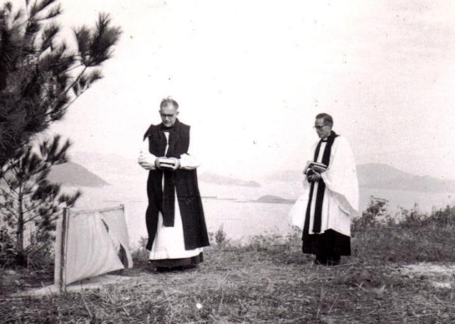
Interstingly, the picture of the clergymen in my original question is not dissimmilar to one I came across when I Googled Deerhill Bay. http://outdoors.webshots.com/photo/1153805806052743881eBNOUt I wonder if this means there is open land there still and maybe the plaque still stands. Would have been nice to have heard something from the Anglicans if it has been knocked down. My Uncle Hugh was still alive when they sold the home and lands.
Again thanks and sorry for another problem. Sean
Comments
Deerhill Bay
Hi Sean
There is still some open land there but I'm not sure if there is public access - although it may be accessible to people who live on the development.
I did send an email to Tai Po District COuncil afew weeks ago asking about the stone, but although they have acknowledged receipt, they have yet to get back to me with any information.
I'll post here if I hear anything.
Cheers
Phil
Thanks Phil for going to
Thanks Phil for going to so much trouble.
Did you manage to have a look at the picture in the link I sent? Looked like a bigger version of the eycaliptus(?) that the bishop seems to be standing under. Or maybe it's my imagination.
If you want to send me a message at infohklegacy@gmail.com will send you my own email back if it suits and nakes life easier.
Sean
Sean It certainly looks as
Sean
No problem, anything Tai Po related is guaranteed to pique my interest. It certainly looks as though it could be the same place, albeit from a slightly different angle. And as to it being the same tree - stranger things have been known.
The council have said they will get back to me this month, so let's wait and see if they have anything. I'm not too confident because they don't usually have access to this type of information other than through members' personal memories. If I get the chance one day I may wander down and ask the guards at the front gate.
Cheers
Phil
re: Deerhill Bay
Sean,
This was a long way out of town in John 1's time. Any ideas what he bought it for?
I did wonder if it was the site of the bungalow by the sea, but the islands in the background don't match up, so not likely.
Regards, David
Deerhill Bay
Some time back we were discussing the likelihood of John1 dealing opium and in the course of that thread somebody said that Landowner became the occupation of opium farmers.
Well John1 was not a "farmer" but he did put his occupation down as Landowner when his youngest son was born!
Maybe he really was a landowner and bought plots all over the place. Will send you a piece I am constructing to insert into the web page.
All just suposition but it is another pointer to his career.
Regards, Sean
Tai Po Bungalow for Europeans
Dated June 10, 1911
Not Deerhill Bay but this may explain the lure to Tai Po.
.
Tai Po Bungalow
Still exists and is currently used by the Norwegian International School as a Kindergarten. Assuming that's the place being referred to.
Deerhill Bay
Hi Phil,
Out of curiosity what was the previous Chinese/Cantonese name of the Deerhill Bay area?
Cheers!
Pak Shek Kok?
To be honest Moddsey I don't know, but I would guess it was all part of what is still called Pak Shek Kok (白石角).
Cheers, Phil
Dearhill Bay
moddsey, phil,
is it my stupidity of are you suggesting that the pictures of the partially built bungalow I posted some time ago is the one you are referring to?
Sean
no, it's not the same
I think moddsey was just highlighting the fact that Tai Po had (and still has?) a certain allure...well, at least I think it has :-)
Tai Po Kau
I was reading Paul Tsui's memoirs the other day and Chapter 4 paragraph 6 makes a mention of Tai Po kau (which perhaps Deerhill Bay is still part of?) and the fact that it was a "Eurpoean Residential Reserve". Here is a link but I have quoted the relevant text below: http://www.galaxylink.com.hk/~john/paul/memoir3.htm
"...before coming to Taipo Kau, a European Residential Resserve[sic], in which only Europeans might apply and be granted a licence from the Governor to build a house to live within the limits of the Reserve"
I wonder if this is how the Olsons came to have the land in this area? It would be interesting to find a map with this reserve marked on it (assuming it was demarcated differently to the current nature reserve).
re: Tai Po Kau
Where today's maps have Tai Po Kau covering a large area, a 1924 map (Plate 5-3, Mapping Hong Hong) shows Tai Po Kau as a small village, just south-west of the western entrance to that short section of railway tunnel. Google Maps shows "Tai Po Kau Sun Wai" in about the same place today.
"The Lookout" is nearby, and may be related to what Paul Tsui described?