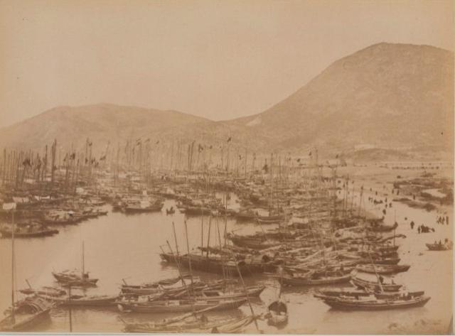
That would give a beach on the right, but then Ap Lei Chau looks wrong as the higher hill should be on the left. Maybe the photo has been printed switched left-right, which sometimes happens.
I guess that might also be somewhere near the present day junction of the Apleichau Bridge and Wong Chuk Hang Road, ie, somewhere along the Shell Gas station and the technical school.
I guess we would need other older photos or maps for reference. I'll dig out my 1964 arial photo book and see if it could get me somewhere.
The other photo of the girl has some huts in the near background. I wonder if any of the existing Aberdeen photos on-site has anything like that.
I initially thought it would have been from further south (around where Ocean Park starts) so the small hill on the left would be Ap Lei Pai. But now I can see that the larger hill is actually in front.
Perhaps it is Ap Lei Pai on the left but seen directly from the north?
edit: Just seen T's response and I think he is right.
I guess a first glance of the previous comment I have mixed it up with the other photo with a girl vege merchant.
The more I look at this 'unknown' photo the more I doubt it as the hill does not seem to match Yuk Kwai Shan. Now I wish we could blow up the photo for more details.
I have a suggestion. Try to save the photo and flip it horizontally. That's more like it. The view angle would be more or less the same as the girl merchant.
The view angle looked right, but the elevation and the lens in use is to be considered as well. The older photo seemed to be taken closer to the sea level while the photographer was elevated in the later one.
The exact location of the photographer is yet to be determined. It would be very difficult as the landscape and the environment had changed a lot. Land had been reclaimed, fields levelled and filled up....... Without old maps and aerial photos it would simply be speculation.
if it is the same location (it looks likely) then the angle is definitely wrong because the mountains don't quite match up. The general shape is the same but when you look closer the ridgelines don't match. I'm not sure whether that means a move to the left/right/up/down etc.
After checking the Aberdeen Aerial on page 38 I believe it fits. Back in the early 1960's the reclamation in the Aberdeen/Apleichau harbour had not even started yet.
My approximation of the location of the photographer of the older photo would be somewhere near the water front at the curve of the Old Aberdeen Main Street, just in front of the slope up to the former Marine Police Station. The newer photo might be taken somewhere near the Marian Police Station.
Moddsey, nice work with the flip & matching. The newer view looks as though it was taken from higher up the hill, but otherwise it's a good match.
T, I agree with your place for the photographer's location. Here's the layout of the original coastline:
HF, I love looking at these old Albumen prints, though I think they typically cost several hundred US$ each, is that about right? A bit too expensive for me to think about collecting.
It's a shame the albumen isn't clearer - if the land stretches from the beach unbroken to the hill in the background, Shau Kei Wan makes more sense. If there is sea between them (eg signs of masts), that points to Aberdeen.
HF, The enlargement certainly shows the land continues to the hills, which should rule out the Aberdeen view we saw earlier.
There aren't any landmarks that I recognise. One thing that's unusual in the enlargement is that I can't see any permanent buildings - everything is a matshed. So maybe somewhere where development is just beginning?
I think the best way to describe HF's photo is to disregard the hills in the background in the photo below. The outline of the hills in the foreground is similar to the albumen photo.
The view I believe is of Ap Lei Chau. The small hillock in the centre is also similar to the albumen photo.
I went to Hong Kong Heritage Museum today and saw this photo. It said it was taken at Cheung Chau around 1898. This photo was included in Lockhart's Report in 1898.
Are you talking about your unknown photo at the very top of this thread? If so, it would be a bit odd to say it was Cheung Chau because the skyline didn't seem to match. I will take a second look the next time I go there.
Looking at the photo sequence. It is from a series of photos depicting the acquisition of the NT and the demarcation of the new border in 1898. Perhaps Deep Bay, NT.
Comments
Re: Unknown
Definitely Aberdeen Bay!
Aberdeen
yes, looks like Ap Lei Chau in the background.
Photographer's location?
I'm having trouble working out where the photographer would have been standing.
First I thought they could be at about the place of the red marker, looking in the direction of the blue line:
[gmap line=22.245535710313067,114.16344666489749 + 22.241881316356935,114.15842556962161 |markers=small red::22.246012363366283,114.16439080247073 |align=Center |zoom=15 |center=22.242033584472928,114.16245460510254 |width=400px |height=350px |control=Small |type=Satellite]
That would give a beach on the right, but then Ap Lei Chau looks wrong as the higher hill should be on the left. Maybe the photo has been printed switched left-right, which sometimes happens.
Any ideas?
Re: Photographer's location
Hi there,
I guess that might also be somewhere near the present day junction of the Apleichau Bridge and Wong Chuk Hang Road, ie, somewhere along the Shell Gas station and the technical school.
I guess we would need other older photos or maps for reference. I'll dig out my 1964 arial photo book and see if it could get me somewhere.
The other photo of the girl has some huts in the near background. I wonder if any of the existing Aberdeen photos on-site has anything like that.
Best Regards,
T
Ap Lei Pai?
I initially thought it would have been from further south (around where Ocean Park starts) so the small hill on the left would be Ap Lei Pai. But now I can see that the larger hill is actually in front.
Perhaps it is Ap Lei Pai on the left but seen directly from the north?
edit: Just seen T's response and I think he is right.
Re: Photographer's location
Hi there,
I guess a first glance of the previous comment I have mixed it up with the other photo with a girl vege merchant.
The more I look at this 'unknown' photo the more I doubt it as the hill does not seem to match Yuk Kwai Shan. Now I wish we could blow up the photo for more details.
Best Regards,
T
Re: Flip it horizontally
Hi there,
I have a suggestion. Try to save the photo and flip it horizontally. That's more like it. The view angle would be more or less the same as the girl merchant.
Best Regards,
T
Thanks a lot. I'm glad to
Thanks a lot. I'm glad to find this website. Previously I couldn't consult anyone about where/when of the photo.
I saw this albumen print from a dealer and I'm wondering whether I should buy it.
I think there are not many photos for Aberdeen during the early stage.
BTW, anyone here like collecting original albumen print?
HF
The Horizontal Flip
When I looked at the photo again, I had the same impression that the original photo should be flipped horizontally.
Here is the comparison.
Similar, but the location of
Similar, but the location of the beach doesn't seem correct.......
Re: Semilar, but the location of the beach
Hi there,
The view angle looked right, but the elevation and the lens in use is to be considered as well. The older photo seemed to be taken closer to the sea level while the photographer was elevated in the later one.
The exact location of the photographer is yet to be determined. It would be very difficult as the landscape and the environment had changed a lot. Land had been reclaimed, fields levelled and filled up....... Without old maps and aerial photos it would simply be speculation.
Best Regards,
T
if it is the same location
if it is the same location (it looks likely) then the angle is definitely wrong because the mountains don't quite match up. The general shape is the same but when you look closer the ridgelines don't match. I'm not sure whether that means a move to the left/right/up/down etc.
After checking the aerial photo I believe it fits
Hi there,
After checking the Aberdeen Aerial on page 38 I believe it fits. Back in the early 1960's the reclamation in the Aberdeen/Apleichau harbour had not even started yet.
My approximation of the location of the photographer of the older photo would be somewhere near the water front at the curve of the Old Aberdeen Main Street, just in front of the slope up to the former Marine Police Station. The newer photo might be taken somewhere near the Marian Police Station.
My 2 cents.
T
Aberdeen
Moddsey, nice work with the flip & matching. The newer view looks as though it was taken from higher up the hill, but otherwise it's a good match.
T, I agree with your place for the photographer's location. Here's the layout of the original coastline:
HF, I love looking at these old Albumen prints, though I think they typically cost several hundred US$ each, is that about right? A bit too expensive for me to think about collecting.
Regards, David
Yap...it is pricey, I'm still
Yap...it is pricey, I'm still wondering whether I should buy it or not. Let's see how much bonus I get this year...if any :-)
I also collected stereoview, which is much cheaper.
I still have several "unknown" photo which I need help. I will post them when I'm less busy (too busy to to take picture/scan it)
Another suggested area
Picture this suggests that the area is Shau Kei Wan!
http://www.picturethiscollection.com/exhibitions/detail/000001495/page1/
1920s Shau Kei Wan. I think the Aberdeen comparison matches closer. Any ideas?
re: Another suggested area
I think your Aberdeen postcard is a better match.
It's a shame the albumen isn't clearer - if the land stretches from the beach unbroken to the hill in the background, Shau Kei Wan makes more sense. If there is sea between them (eg signs of masts), that points to Aberdeen.
I don't think it was Aberdeen
I acquired this albumen recently. I don't think it was taken in Aberdeen (please see the enlarged part print)
re: I don't think it was Aberdeen
HF, The enlargement certainly shows the land continues to the hills, which should rule out the Aberdeen view we saw earlier.
There aren't any landmarks that I recognise. One thing that's unusual in the enlargement is that I can't see any permanent buildings - everything is a matshed. So maybe somewhere where development is just beginning?
Regards, David
unknown
I can recall seeing this photo in a collection some years ago, and it was marked as boats sheltering from a typhoon at Sha Kei Wan.
regards
Ho Lim-peng
Re: Horizontal Flip
I think the best way to describe HF's photo is to disregard the hills in the background in the photo below. The outline of the hills in the foreground is similar to the albumen photo.
The view I believe is of Ap Lei Chau. The small hillock in the centre is also similar to the albumen photo.
1950s Ap Lei Chau 'or earlier'
re: unknown
grries of shots from aldrich bay in 1980 (confusingly called aberdeen in photos here). May help:
http://www.flickr.com/photos/lwdemery/5037890239/in/set-72157613802780399/
Cheung Chau
I went to Hong Kong Heritage Museum today and saw this photo. It said it was taken at Cheung Chau around 1898. This photo was included in Lockhart's Report in 1898.
Cheung Chau?
HF,
Are you talking about your unknown photo at the very top of this thread? If so, it would be a bit odd to say it was Cheung Chau because the skyline didn't seem to match. I will take a second look the next time I go there.
Best Regards,
T
Cheung Chau
Yes, I'm referring to my unknown photo at the very top of this thread.
Re: Aberdeen
I had a hunch I would find your photo in the UK Archives as seen here
Location given as Chik Wan, Deep Bay. Date: 1898
excellent find by moddsey.
excellent find by moddsey. The question now is - where is Chik Wan? It's not a name I recognise. I assume Deep Bay refers to Shum Wan at Aberdeen?
Re: Chik Wan, Deep Bay
Hi there,
Chik Wan 赤灣 is over in Shenzhen, across the water from the CLP Lung Kwu Tan Power Plant on the coast, NW of Castle Peak.
Best Regards,
T
psOn Google Maps today, Chik Wan is known as Chiwan.
Re: Aberdeen
Looking at the photo sequence. It is from a series of photos depicting the acquisition of the NT and the demarcation of the new border in 1898. Perhaps Deep Bay, NT.
Deep Bay
ah I see. Many thanks T and Moddsey.
Deep Bay
Thanks, Moddsey. By the way, this album is really great, I wish I could acquire the rest of photos.......