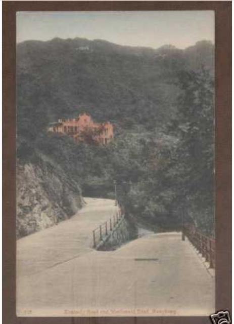
I wonder if the postcard's title is right. I think we're looking at Kennedy Road to the left, with the road to the right heading down into the barracks area. So the junction in the foreground would be about here on the map:
Thanks Annelise, that helps. I think the photo is of the junction shown in the top-right corner of the map, between the R and O of 'ROAD'. Pity the map doesn't show what the downward sloping road led to.
I think it is the junction at the letter Y of Kennedy. Cover the upslope road with your hand, and you will see that the other road is relatively flat, likely making it Kennedy Road. The "down" is actually a turn to the right, as in the Map.
The large building is also on the map, on MacDonnell Rd, but no name shown, I'm afraid.
From the photo, I was looking for a junction on the map where the left-hand road:
if projected ahead in a straight line would meet the large building
would curve away to the left out of view
The R-O junction fits both requirements, and gets my vote.
The other clue is in the newer photo. The building with the white gables and circular opening is the style of the army's barracks buildings, confirming the left-hand road is Kennedy Road running around the edge of Victoria Barracks.
Macdonnell Road commenced construction in 1891 from its western junction with Garden Road. The road was 20 ft wide. Bridges were erected over the Albany Nullah and Peak Tramway. In 1899, Macdonnell Road was extended to Kennedy Road and finally completed. In that year, Tramway Path was also built to provide access to residents on both roads.
The first land sales on Macdonnell Road took place in 1896, the same year as Belilios bought Kingsclere.
Getting back to the photo, I think it can be dated to around 1900.
Here is a photo of Macdonnell Rd sloping downhill to meet up with Kennedy Road. I am dating it to the 1910s decade. The large building and Kingsclere can be seen.
David, could you group the info about Kingsclere onto a single page? It would make it easier for reference. Thanks.
When I looked at the 1910s photo, my first impression was that it was taken at the eastern end of Macdonnell Road where it meets up with Kennedy Road (the currrent junction). But having rotated the map, there is no line of sight projection with the large building that appears above the down sloping road.
The section of Kennedy Rd between Garden Road and Macdonnell Rd has always followed the contour of the hill. Therefore, I do not think the sloping road on the left is Kennedy Road. Any other ideas?
Perhaps we must go forward - the building on the 1901 map may not be the one in the postcard.
I have a 1922 map by the PWD that I unearthed at the Lands Department in North Point (Quarry Bay MTR station exit) but I asked for one quadrant and it does not show this view.
When was Barker Rd built ? I think I see some houses below the ridgeline.
Also, if we can identify the house in the second postcard with the distinctive round tower on one side, then we can do the line-of-sight check.
Barker Road from Plantation Rd to Magazine Gap was completed in 1898. Before the completion of the road, three large building sites had been sold with one site in an advanced state of construction.
Moddsey, I did a quick search for 'kingsclere', and most of the info is on the page for the Kingsclere Place. What extra info would be good to have there?
Comments
MacDonnell?
I wonder if the postcard's title is right. I think we're looking at Kennedy Road to the left, with the road to the right heading down into the barracks area. So the junction in the foreground would be about here on the map:
[gmap markers=small red::22.277107158690136,114.16273355484009 |align=Center |zoom=17 |center=22.277262697940692,114.16266918182373 |width=350px |height=350px |control=Small |type=Map]
1901 Map to the rescue
click here to go straight to the Government map
The intersection was this sharp. The road must have been rebuilt for car traffic instead of sedan chairs
re: 1901 Map to the rescue
Thanks Annelise, that helps. I think the photo is of the junction shown in the top-right corner of the map, between the R and O of 'ROAD'. Pity the map doesn't show what the downward sloping road led to.
Optical illusion
I think it is the junction at the letter Y of Kennedy. Cover the upslope road with your hand, and you will see that the other road is relatively flat, likely making it Kennedy Road. The "down" is actually a turn to the right, as in the Map.
The large building is also on the map, on MacDonnell Rd, but no name shown, I'm afraid.
I still think it's Kennedy Road
From the photo, I was looking for a junction on the map where the left-hand road:
The R-O junction fits both requirements, and gets my vote.
The other clue is in the newer photo. The building with the white gables and circular opening is the style of the army's barracks buildings, confirming the left-hand road is Kennedy Road running around the edge of Victoria Barracks.
I rest my case your honour!!
Re: Kennedy and Macdonnell Roads
From the public records:
Macdonnell Road commenced construction in 1891 from its western junction with Garden Road. The road was 20 ft wide. Bridges were erected over the Albany Nullah and Peak Tramway. In 1899, Macdonnell Road was extended to Kennedy Road and finally completed. In that year, Tramway Path was also built to provide access to residents on both roads.
The first land sales on Macdonnell Road took place in 1896, the same year as Belilios bought Kingsclere.
Getting back to the photo, I think it can be dated to around 1900.
Here is a photo of Macdonnell Rd sloping downhill to meet up with Kennedy Road. I am dating it to the 1910s decade. The large building and Kingsclere can be seen.
David, could you group the info about Kingsclere onto a single page? It would make it easier for reference. Thanks.
Re: Kennedy Road or Macdonnell Road
When I looked at the 1910s photo, my first impression was that it was taken at the eastern end of Macdonnell Road where it meets up with Kennedy Road (the currrent junction). But having rotated the map, there is no line of sight projection with the large building that appears above the down sloping road.
The section of Kennedy Rd between Garden Road and Macdonnell Rd has always followed the contour of the hill. Therefore, I do not think the sloping road on the left is Kennedy Road. Any other ideas?
Built after 1901
Perhaps we must go forward - the building on the 1901 map may not be the one in the postcard.
I have a 1922 map by the PWD that I unearthed at the Lands Department in North Point (Quarry Bay MTR station exit) but I asked for one quadrant and it does not show this view.
When was Barker Rd built ? I think I see some houses below the ridgeline.
Also, if we can identify the house in the second postcard with the distinctive round tower on one side, then we can do the line-of-sight check.
Re: Barker Road
Barker Road from Plantation Rd to Magazine Gap was completed in 1898. Before the completion of the road, three large building sites had been sold with one site in an advanced state of construction.
re: Grouping Kingsclere info
Moddsey, I did a quick search for 'kingsclere', and most of the info is on the page for the Kingsclere Place. What extra info would be good to have there?