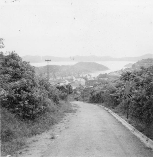
Couldn't make out exactly where was this photo taken yet. But it should be somewhere around the Lower Aberdeen Reservoir area. At least the angle was right.
Thank you again T for your help with these photos. I think I shall have to see if I can find a good map with the places you mention on it as, until I found this brilliant site, I was not familiar with HK at all, apart from the little that my husband told me of course. He was based at HQLF the roof of which appears in one of the other photos.
There's the chimney of the Aberdeen Dockyards visible in the centre of this photo.
A possible route would be from Victoria Barracks up to Magazine Gap (not sure exact path), then down Coombe Road to Wanchai Gap, and down Aberdeen Reservoir Road to Aberdeen.
Do you think he was walking or driving? Aberdeen Reservoir Road is closed to traffic now, but may have been open in the 1950s.
The ad-hoc field trip today confirmed, the photo seemed to be showing the lower part of the Aberdeen Reservoir Road, before the housing estate was built in the 1960's and before the road was widened. If you go to Google Maps and key in the coordinates 22.25282 & 114.15771 you should be around with a 25 m radius of where the photographer was standing.
I took this photo yesterday a bit further up the slope:
Thank you very much. Your photo shows just how much all this has changed since my husband was there but I am trying to follow his route on this outing on google maps and I'm learning! How far do you think he would have walked from Victoria Barracks to here?
I frequent a similar route the from Aberdeen, but I had not measure it ever. My estimate would be around 10 km. When I am free I'll have a rough measure using Google Maps.
For 10 km it would be just a leasure walk of just a few hours despite Magazine Gap Road is a bit challenging to some.
I tried to plot a possble path in Google Earth from the then Barracks up the slope, Magazine Gap, then down to Wanchai Gap to Aberdeen. It was well within 10 km. I will write up a turn by turn estimate later for this.
If it was a leasure walk, stopping here or there for sight seeing, the walk could take three or four hours, depends on speed. If one goes for speed he could probably do it within two hours, but that won't have time for sight seeing.
Sounds as though this would have been an easy walk for my husband but how would he have got back? Some form of public transport perhaps or perhaps it was a day's outing and a round trip.
There are many foot paths or service roads on the island. If one elect to walk there is always a way back.
Back then, there was a franchise called China Motor Bus, providing public bus service on the island. I wasn't born yet in the 1950's, but I believe there were at least one bus routes going between Central & Aberdeen, and another between Western & Aberdeen. Both bus routes went along the western side of the island. One along Pokfulamd Road, the other along Victoria Road. The one running between Central & Aberdeen still exist today despite CMB is long gone when it lost its franchise in 1998.
Other than buses, TAXI should be available. Or the military could have their own pre-arranged transport, I presumed?
Thanks for that. I think a bus would be the most likely means of transport as I doubt very much if the military would have provided mere national servicemen with transport although I am wondering if the launch in some of my other photos did belong to the combined forces. I think my husband did quite a lot of travelling around by boat and I had the impression that this was something that went with the job but I have no proof and I could well be wrong!
I see the Right Hand Side of this photo. This is a ladder field's place. Well, this is Aberdeen Chinese Permanent Cemetery.
(1) POK FU LAM RESERVOIR ROAD cannot see it. Impossible!
(2) PEEL RISE can see it. The ladder field will very large and contain graves. The position will change to Left Hand Side. But this photo can't see graves very clear. Impossible.
(3) ABERDEEN RESERVOIR ROAD can see the place in Right Hand Side and can't see graves very clear. Possible!
Therefore, ABERDEEN RESERVOIR ROAD is only one solution. I think this photo is nearby YUE KWONG CHUEN / ABERDEEN RESERVOIR ROAD.
Comments
Re: Victoria to Aberdeen 1954
Hi there,
Couldn't make out exactly where was this photo taken yet. But it should be somewhere around the Lower Aberdeen Reservoir area. At least the angle was right.
Best Regards,
T
Re Victoria to Aberdeen 1954
Thank you again T for your help with these photos. I think I shall have to see if I can find a good map with the places you mention on it as, until I found this brilliant site, I was not familiar with HK at all, apart from the little that my husband told me of course. He was based at HQLF the roof of which appears in one of the other photos.
Best regards.
Pauline.
The outing
There's the chimney of the Aberdeen Dockyards visible in the centre of this photo.
A possible route would be from Victoria Barracks up to Magazine Gap (not sure exact path), then down Coombe Road to Wanchai Gap, and down Aberdeen Reservoir Road to Aberdeen.
Do you think he was walking or driving? Aberdeen Reservoir Road is closed to traffic now, but may have been open in the 1950s.
Regards, David
Re The Outing
Hi David,
My husband would have been walking when he took these photos I'm sure. I think he spent a lot of his free time walking, climbing and exploring.
Best Regards,
Pauline.
Re: The lower part of the Aberdeen Reservoir Road
Hi there,
The ad-hoc field trip today confirmed, the photo seemed to be showing the lower part of the Aberdeen Reservoir Road, before the housing estate was built in the 1960's and before the road was widened. If you go to Google Maps and key in the coordinates 22.25282 & 114.15771 you should be around with a 25 m radius of where the photographer was standing.
I took this photo yesterday a bit further up the slope:
Best Regards,
T
Changes on Aberdeen Reservoir Road
Hi T,
Thank you very much. Your photo shows just how much all this has changed since my husband was there but I am trying to follow his route on this outing on google maps and I'm learning! How far do you think he would have walked from Victoria Barracks to here?
Pauline.
Re: How far it was from Victoria to Aberdeen
Hi there,
I frequent a similar route the from Aberdeen, but I had not measure it ever. My estimate would be around 10 km. When I am free I'll have a rough measure using Google Maps.
For 10 km it would be just a leasure walk of just a few hours despite Magazine Gap Road is a bit challenging to some.
Best Regards,
T
Re: Plotting the path
Hi there,
I tried to plot a possble path in Google Earth from the then Barracks up the slope, Magazine Gap, then down to Wanchai Gap to Aberdeen. It was well within 10 km. I will write up a turn by turn estimate later for this.
If it was a leasure walk, stopping here or there for sight seeing, the walk could take three or four hours, depends on speed. If one goes for speed he could probably do it within two hours, but that won't have time for sight seeing.
Best Regards,
T
Leisure Walk
Thanks again,
Sounds as though this would have been an easy walk for my husband but how would he have got back? Some form of public transport perhaps or perhaps it was a day's outing and a round trip.
Best regards, Pauline.
Re: Leisure walk
Hi there,
There are many foot paths or service roads on the island. If one elect to walk there is always a way back.
Back then, there was a franchise called China Motor Bus, providing public bus service on the island. I wasn't born yet in the 1950's, but I believe there were at least one bus routes going between Central & Aberdeen, and another between Western & Aberdeen. Both bus routes went along the western side of the island. One along Pokfulamd Road, the other along Victoria Road. The one running between Central & Aberdeen still exist today despite CMB is long gone when it lost its franchise in 1998.
Other than buses, TAXI should be available. Or the military could have their own pre-arranged transport, I presumed?
Best Regards,
T
Buses, taxis or military transport?
Thanks for that. I think a bus would be the most likely means of transport as I doubt very much if the military would have provided mere national servicemen with transport although I am wondering if the launch in some of my other photos did belong to the combined forces. I think my husband did quite a lot of travelling around by boat and I had the impression that this was something that went with the job but I have no proof and I could well be wrong!
Best regards. Pauline.
Reply of Victoria to Aberdeen 1954
Dear Everybody:
I see the Right Hand Side of this photo. This is a ladder field's place. Well, this is Aberdeen Chinese Permanent Cemetery.
(1) POK FU LAM RESERVOIR ROAD cannot see it. Impossible!
(2) PEEL RISE can see it. The ladder field will very large and contain graves. The position will change to Left Hand Side. But this photo can't see graves very clear. Impossible.
(3) ABERDEEN RESERVOIR ROAD can see the place in Right Hand Side and can't see graves very clear. Possible!
Therefore, ABERDEEN RESERVOIR ROAD is only one solution. I think this photo is nearby YUE KWONG CHUEN / ABERDEEN RESERVOIR ROAD.
Thank you for your watching and attention.
Best Wishes and Merry Christmas
kitsonkwang2012 v_(;->)_v