In science there is a term called data mining – extraction of new informations and interrelations from already existing data. I had the idea of image mining – using images on Gwulo for new (unreported) connections and timelines.
My special interests are buildings on Barker Road, so I chose from Gwulo photos of Victoria Gap and the Peak Tram with Barker Road on them.
Let’s start in 1890. This one was probably taken from Severn Road and shows the Peak Tram and Mount Austin.
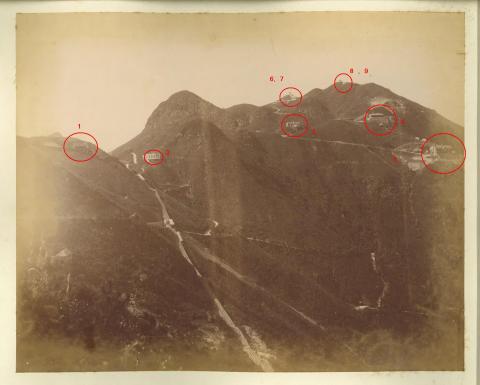
I cropped a detail from it and tried to improve the quality, unfortunately not too successful.
On Victoria Gap is the The Peak Tram, upper terminus [????- ] and #6 Police Station [1869-1954]. In the lower centre the Peak Tram is visible just above Plantation Road Station (later renamed to Barker Road station). Right-hand side from the tram is Plantation Road going down to (old) Peak Road, later this part of the road was allocated to Barker Road. Left-hand side a road continues. I’m not familiar with the history of roads on the peak and their building dates. So this could be Barker Road, but I won’t exclude Plantation Road.
Now we need a bit of imagination due to poor resolution. Maybe a hundred meters along the road there is a building, it might be “The Cottage” at Peak No. 126 (RBL 97). Going left from that I cannot see any houses along the road. But there is one at the lower left-hand side. The only one I know that would fit is Martinhoe , or a predecessor.
Next in our timeline is an image from about 1910:

This photographer stood somewhat more downhill than the first one, possibly on Barker Road where No. 31 is today. Again, the Peak Tram is at the station. On the left is Barker Road with stone walls for landslide prevention, also a small part of Plantation Road is visible, going uphill above the first stone wall. Identified buildings are: #6 Police Station [1869-1954], Peak Depot - Water Supplies Department [1910- ], and Quarndon [1902-????]. At that time Glenshiel wasn’t built yet.
Going ahead in time we come to four images, all not very precise in their attributed creation dates. Certainly they were all taken after the 1910 one as Glenshiel appears on all of them. I put them into an order that I think to be reasonable, but I might be wrong.
Next is from about 1915:
At that time Glenshiel (Glenshiel - Epworth Lodge (1949) [????- ]) was already built. We also see Mount Austin Barracks [1897-????].
From the same time period is http://gwulo.com/atom/23348 showing Barker Road Station in different years.
I cropped the 1915 part. This image was taken from Plantation Road, behind (below) the fence is Barker Road.
Behind the tracks is Glenshiel (Glenshiel - Epworth Lodge (1949) [????- ]) with a pavilion in front. The roof looks a bit different compared to the image above. Possibly this is due to artists impression while hand colouring, or a real change.
Now it’s time to have a look on a map. There is one from 1909 . I cropped a detail showing the area we are talking about.
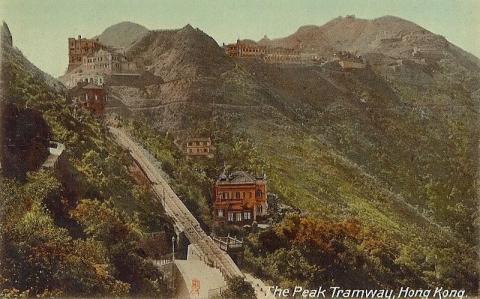
We need it for our next image, also dated to somewhat around 1915:

Here, the photographer stood at a lower altitude, maybe on Chatham Path or below (today’s) 22, Barker Road. Right-hand side we see Glenshiel (Glenshiel - Epworth Lodge (1949) [????- ], painted white in this one). The red building above Barker Road is Ligoniel (Ligoniel and The Farm - RBL 101 [????- ]) at Peak No. 123.
Following Barker Road to the left (south-east) we see two white houses. I believe the first one is “The Cottage” at Peak No. 126 (RBL 97), later named or rebuilt as Villa Blanca . The next should be Tantallon at Peak No. 126A (RBL 121), on an elevated platform above Barker Road. This seems to be obvious from the 1909 map,
but when we look at the 1912 map , (detail below), it could also be Capsnimum (?) at RBL 125.
Or Tai Wo from the 1924 map (detail below):
The fourth in this series is dated to about 1920, but possibly earlier.

No real change compared to first one of the 1915th series (http://gwulo.com/atom/23349). Houses colours are different, and on this one Ligoniel (Ligoniel and The Farm - RBL 101 [????- ]) is visible just above Findlay Path.
Let’s make a time-step of about 5 years to reach 1920. Here we have:
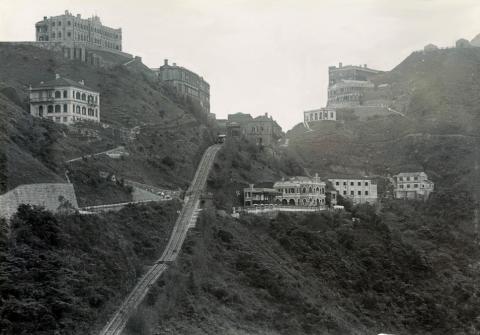
This one shows Victoria Gap from a similar angle as in the 1910 one. What we can see clearly here is a pavilion left of Glenshiel (to be seen on the 1909 map and as RBL108 in the 1915 Victoria Gap map (below):

On the right-hand side is Peak Depot - Water Supplies Department [1910- ] (RBL 83). In between these two is another building, possibly “Chair Coolies House” as shown on the 1915 Victoria Gap map.
Last one is from Betty Steel's photos from the 1920s (1920-1930):

Probably it was taken (similar to the 1890 one) from Severn Road. On Barker Road, The Cottage and Tantallon are visible at the extreme left-hand side. And there is a new feature at the Peak Tram: Barker Road Station has a roof – now it’s a station and not a mere stop! Further on Barker Road we have Glenshiel with the pavilion left of it. From this angle it’s easy to see that both Chair Coolies House and Peak Depot are higher up the hill, they are on the (old) Peak Road and not on Barker.
More houses can certainly be identified, but I’m not familiar with these. Any suggestions are welcome.
For me it’s amazing to see how this small part of Hong Kong changed over just 40 years, and this happened already nearly one hundred years ago. Of course, half a century later the changes were bigger, but remember, technical resources were much more limited then.
_______________________________________________________________________
Finally, I have a sort of bonus image. I couldn’t find any similar images from the following decades as (downhill) photos from the upper terminal of the Peak Tram were more popular. The next one I found is from 1983(!):
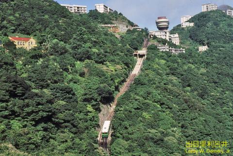
I think it was taken from a similar spot as the 1915 one .
A lot of things have changed on the gap and Mount Austin, more and higher buildings including Peak Tower I [1972-1994]. On the left-hand side is a house with a red roof, this is Villa Blanca . Compared to the building on earlier photos it has at least a different roof, quite likely it was rebuilt after the war (1945-1950).