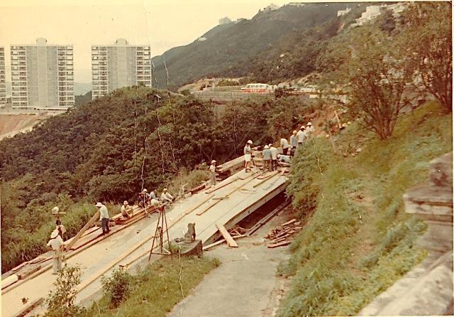
This shot was recently sent to me by my brother, who I think took it in June 1966. It shows repair work on the stretch of road at the top of Magazine Gap Rd. which was completely washed away by heavy rains. We were living at the Government flats which are in the picture, Mansfield Road, which were cut-off by the road slip. There were several other landslides on Magazine Gap Rd. which meant it was quite a while before the Peak was accessible by car.
Date picture taken
30 Jun 1966
Shows place(s)
Shows event(s)
Comments
Cabin fever!
We had been 'stuck' in our building for a few days, when my father decided that he and I should try to hike into town to get some food! To this day, I think he was just bored and needed to get out! We hiked down Magazine Gap Road, through hip-deep mud which was still oozing out of the scars left by several landslides! Workmen looked on in atsonishment! I was 11, in plimsoles and carrying a duffle bag. We got into town, which was strewn with abandoned cars, fallen trees and litter everywhere. We found a compradore (!) open and bought spam and some bread and began our hike back. We returned via Old Peak Rd, the top stretch of which is cobbled (my father said it was a sedan-chair road) and which was in pretty good condition. No landslides. As we rounded the bend of Barker Road, overlooking Guildford and Mansfield, we saw helicopters on the playground there, dropping food off to the residents! It was good fun, very exciting - but extremely dangerous for sure!
Peak Landslide
There was a major landslide slightly further up the road that's visible in the photo in the very early 1980s, that took again out the road to the Peak. For a few days people heading to the peak had to climb over a temporary bridge and use the transport stuck on the other side (an adventure going to school)
Re: 1966 Peak Landslide and Helicopter Airlift
Hi Bails - appearing on ebay as seen here