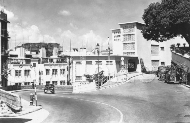
This is a photo taken at the intersection of PokFuLam Road and High Street. The winding road on the left is PokFuLam Road and the road to the right is High Street. This location is about a mile from the beginning of PokFuLam Road which intersects Queen’s Road West. The right side of the photo shows part of a driveway to the Ling Yuet Sin infirmary. The building in the middle and the right side of the photo is Li Sing Primary School. Judging from the model of cars in the photo, the primary school looks brand new, and the size of the Banyan tree in the middle of the photo, the photo appears to have been taken in the mid-fifties, 1955 or 56.
On the left side, not shown in the photo, is Water Street which runs downhill and intersects Queen’s Road West. On the right side, also not shown in the photo, is a convenience store and next to the store is an uphill stairway connecting to Hing Hon Road. Next to the stairway is an open ditch which is part of the rainwater runoff towards Victoria Harbour. When Water Street was built, the runoff was paved over except a section between Queen’s Road West and Des Voeux Road which remained an open ditch until the sixties when it was paved over to facilitate car traffic. So, the only open ditch part of this runoff is next to the stairway to Hing Hon Road now.
Since I mention High Street here, I hope readers can bear with me my additional comments on this street. High Street belongs to the Sai Ying Pun (or Sei Ying Poon) district and surprisingly, the road system in this area was quite well developed as early as 1860. The Early Map of HK (1859) already showed the existence of this street. The three main streets running from Bonham Road in Mid-level down to the Victoria harbour are Western Street, Centre Street, and Eastern Street. A network of four streets transversing these streets and running horizontally along the hillside are First Street, Second Street, Third Street, and High Street. Logically, High Street should have been called Fourth Street. According to Wikipedia, it used to be called Fourth Street, but the Chinese are superstitious about the number “Four” as it sounds the same as the Chinese word “Death” and so it was changed to High Street. I did some digging but could not find any old HK Map with the name Fourth Street. So, when the name was changed is a mystery to me. The oldest Map I found, dated 1873, shows that this street was already named High Street.
Thank you for taking the time and effort to dig out this piece of information. Looks like the name change from Fourth Street to High Street took place between 1865 and 1870. Hope you don’t mind me bothering you one more time on another street named Yuk Ming Street in Sei Ying Pun. Do you know when this street was built? It “was” a dead-end street that cut into Third Street near St Louis School. The street no longer exists.
I think the reference to Wanchi refers to the old spelling for Wanchai in some primary sources. Probably not Sai Ying Pun. The nullah referred to may be to Stone Nullah as in today’s Stone Nullah Lane. Wanchi Street, the forerunner to Wanchai Road ?
I think High Street was indeed renamed from Fourth Street. Although Wanchi Road sounds a bit puzzling, First Road (and the Chinese names) appear in both years but with different description. Different names of start and end roads, or a typing error?
I observe that the word “Nullah” is a common word found in some older HK maps (usually next to a mountain stream). However, I cannot find this word in the dictionary explaining what it means. When “moddsey” brought up “Stone Nullah Lane” in his discussion, the Chinese name of this street led me to confirm my suspicion on what Nullah actually means. The word “Nullah” in Stone-Nullah Lane was translated as a water channel or waterway in Chinese. This confirms that the word “Nullah” in the map means water channel or waterway which is to bring rainwater from the mountainside down to the sea, essentially a storm drain.
In this case, the description of Fourth Street in “The Chronicle and Directory (1865)” “from Nullah to Wah chi Street” means Fourth Street began from or next to a Nullah and spans to Wan chi Street. This matches the discussion I have in the above text of a storm drain next to the stairway to Hing Hon Road, bringing rainwater from the hillside above, through Water Street, to Victoria Harbour.
As far as Wan chi Street is concerned, it is not defined in the street directory. There is a Wanchi “Road” which everyone knows is in Wanchi. However, Wanchi “Street” is not known. I suspect that it might have been the original name of Eastern Street. In the 1865 edition of The Chronicle and Directory, Eastern Street is not listed. So it might mean that the street might not have been named Eastern Street in 1865. It is possible that originally Fourth Street also ended at Eastern Street instead of continuing on and merging with Bonham Road as that part of the road (from Eastern Street to Bonham Road section) might not have been built in 1865 yet.
Last but not least, I was able to find the 1868 edition of The Chronicle and Directory on the internet. In it, Fourth Street has disappeared, and High Street came into existence. So, the time for the name change from Fourth Street to High Street can now be narrowed down to between 1865 and 1868!
List of streets first to fourth street, in this year without Chinese names.
Additionally listed is Wanchai Street (to be distinguished from Wanchai Road) running from Queen's Road to Fourth Street. It looks indeed that Wanchai Road was renamed Eastern Street. In the 1870s chronicle, the name Wanchai Street is no longer listed, and Eastern Street appears.
Mr. Klaus’s finding confirms that Eastern Street used to be called WanChai Street as late as 1864. Also, Nullah was the name used (before Water Street was built) to mark the start of First, Second, Third, and Fourth Streets. I would like to offer some additional comments if I may:
According to “The Chronicle and Directory”, the storm drain (Nullah) that flows passed Hing Hon Road was used to mark the start of First, Second, Third, and Fourth Streets. This is true for Second, Third, and Fourth Streets. For First Street, It starts at the intersection with PokFuLam Road which is a block (about a quarter of a mile) from the Nullah. So, First Street did not start “at” the Nullah but can be considered starting “near” the Nullah. For The Chronicle and Directory, looks like it was considered close enough.
Second Street did start at Water Street and ended at Eastern Street by name only. The Road continues after passing Eastern Street and gradually curves uphill and merges with Bonham Road. This section of the road might have been built later and is called Hospital Road.
Third Street started at Water Street and ended at Eastern Street originally. On a later date, Third Street was extended westward towards St Louis School and then curved uphill and merged with the intersection of PokfuLam Road, Bonham Road, and Hill Road. (Some old HK maps show that the uphill section of Third Street used to be called Battery Street)
High Street (Fourth Street) started at the intersection of Pokfulam Road and Water Street and ended at Eastern Street. On a later date, it was extended eastward passed Eastern Street, continued uphill, and eventually merged with Bonham Road. This section of the road is still called High Street.
Comments
PokFuLam Rd, High St., & Water St.
This is a photo taken at the intersection of PokFuLam Road and High Street. The winding road on the left is PokFuLam Road and the road to the right is High Street. This location is about a mile from the beginning of PokFuLam Road which intersects Queen’s Road West. The right side of the photo shows part of a driveway to the Ling Yuet Sin infirmary. The building in the middle and the right side of the photo is Li Sing Primary School. Judging from the model of cars in the photo, the primary school looks brand new, and the size of the Banyan tree in the middle of the photo, the photo appears to have been taken in the mid-fifties, 1955 or 56.
On the left side, not shown in the photo, is Water Street which runs downhill and intersects Queen’s Road West. On the right side, also not shown in the photo, is a convenience store and next to the store is an uphill stairway connecting to Hing Hon Road. Next to the stairway is an open ditch which is part of the rainwater runoff towards Victoria Harbour. When Water Street was built, the runoff was paved over except a section between Queen’s Road West and Des Voeux Road which remained an open ditch until the sixties when it was paved over to facilitate car traffic. So, the only open ditch part of this runoff is next to the stairway to Hing Hon Road now.
Since I mention High Street here, I hope readers can bear with me my additional comments on this street. High Street belongs to the Sai Ying Pun (or Sei Ying Poon) district and surprisingly, the road system in this area was quite well developed as early as 1860. The Early Map of HK (1859) already showed the existence of this street. The three main streets running from Bonham Road in Mid-level down to the Victoria harbour are Western Street, Centre Street, and Eastern Street. A network of four streets transversing these streets and running horizontally along the hillside are First Street, Second Street, Third Street, and High Street. Logically, High Street should have been called Fourth Street. According to Wikipedia, it used to be called Fourth Street, but the Chinese are superstitious about the number “Four” as it sounds the same as the Chinese word “Death” and so it was changed to High Street. I did some digging but could not find any old HK Map with the name Fourth Street. So, when the name was changed is a mystery to me. The oldest Map I found, dated 1873, shows that this street was already named High Street.
Fourth Street
The THE CHRONICLE AND DIRECTORY (1865) refers on page 117:
FOURTH STREET, Tai-see-kai,-(from Nullah to Wanchi Street)
[sorry Chinese characters not transcribed]
The 1870 edition (page 48) has no fourth but HIGH STREET.
Thanks & one more question - Yuk Ming St
Thank you for taking the time and effort to dig out this piece of information. Looks like the name change from Fourth Street to High Street took place between 1865 and 1870. Hope you don’t mind me bothering you one more time on another street named Yuk Ming Street in Sei Ying Pun. Do you know when this street was built? It “was” a dead-end street that cut into Third Street near St Louis School. The street no longer exists.
Re: Wanchi Street
I think the reference to Wanchi refers to the old spelling for Wanchai in some primary sources. Probably not Sai Ying Pun. The nullah referred to may be to Stone Nullah as in today’s Stone Nullah Lane. Wanchi Street, the forerunner to Wanchai Road ?
Fourth and High Street
I think High Street was indeed renamed from Fourth Street. Although Wanchi Road sounds a bit puzzling, First Road (and the Chinese names) appear in both years but with different description. Different names of start and end roads, or a typing error?
Re: Yuk Ming Street
Yuk Ming Street does not appear in the 1870 Chronicle. Sorry, don't know more about this street.
More info. on Fourth Street
I observe that the word “Nullah” is a common word found in some older HK maps (usually next to a mountain stream). However, I cannot find this word in the dictionary explaining what it means. When “moddsey” brought up “Stone Nullah Lane” in his discussion, the Chinese name of this street led me to confirm my suspicion on what Nullah actually means. The word “Nullah” in Stone-Nullah Lane was translated as a water channel or waterway in Chinese. This confirms that the word “Nullah” in the map means water channel or waterway which is to bring rainwater from the mountainside down to the sea, essentially a storm drain.
In this case, the description of Fourth Street in “The Chronicle and Directory (1865)” “from Nullah to Wah chi Street” means Fourth Street began from or next to a Nullah and spans to Wan chi Street. This matches the discussion I have in the above text of a storm drain next to the stairway to Hing Hon Road, bringing rainwater from the hillside above, through Water Street, to Victoria Harbour.
As far as Wan chi Street is concerned, it is not defined in the street directory. There is a Wanchi “Road” which everyone knows is in Wanchi. However, Wanchi “Street” is not known. I suspect that it might have been the original name of Eastern Street. In the 1865 edition of The Chronicle and Directory, Eastern Street is not listed. So it might mean that the street might not have been named Eastern Street in 1865. It is possible that originally Fourth Street also ended at Eastern Street instead of continuing on and merging with Bonham Road as that part of the road (from Eastern Street to Bonham Road section) might not have been built in 1865 yet.
Last but not least, I was able to find the 1868 edition of The Chronicle and Directory on the internet. In it, Fourth Street has disappeared, and High Street came into existence. So, the time for the name change from Fourth Street to High Street can now be narrowed down to between 1865 and 1868!
Re: Wanchi
Wanchai or Wan Chai has been known by various names in the past e.g. Wanchi, Wantsai, Ha Wan etc.
A list of Public Markets in 1858 can be viewed here. Wanchi Market is given.
Wanchai Street
Here's an excerpt from The Chronicle and Directory (1864).
List of streets first to fourth street, in this year without Chinese names.
Additionally listed is Wanchai Street (to be distinguished from Wanchai Road) running from Queen's Road to Fourth Street. It looks indeed that Wanchai Road was renamed Eastern Street. In the 1870s chronicle, the name Wanchai Street is no longer listed, and Eastern Street appears.
Good Find
Good find. Thanks. Interesting to see Wanchi/Wanchai also being used in the western part of the city and thus the resultant name change in 1870.
1st, 2nd, 3rd, and 4th streets
Mr. Klaus’s finding confirms that Eastern Street used to be called WanChai Street as late as 1864. Also, Nullah was the name used (before Water Street was built) to mark the start of First, Second, Third, and Fourth Streets. I would like to offer some additional comments if I may:
According to “The Chronicle and Directory”, the storm drain (Nullah) that flows passed Hing Hon Road was used to mark the start of First, Second, Third, and Fourth Streets. This is true for Second, Third, and Fourth Streets. For First Street, It starts at the intersection with PokFuLam Road which is a block (about a quarter of a mile) from the Nullah. So, First Street did not start “at” the Nullah but can be considered starting “near” the Nullah. For The Chronicle and Directory, looks like it was considered close enough.
Second Street did start at Water Street and ended at Eastern Street by name only. The Road continues after passing Eastern Street and gradually curves uphill and merges with Bonham Road. This section of the road might have been built later and is called Hospital Road.
Third Street started at Water Street and ended at Eastern Street originally. On a later date, Third Street was extended westward towards St Louis School and then curved uphill and merged with the intersection of PokfuLam Road, Bonham Road, and Hill Road. (Some old HK maps show that the uphill section of Third Street used to be called Battery Street)
High Street (Fourth Street) started at the intersection of Pokfulam Road and Water Street and ended at Eastern Street. On a later date, it was extended eastward passed Eastern Street, continued uphill, and eventually merged with Bonham Road. This section of the road is still called High Street.