Source: This image came from Flickr, see https://flickr.com/photo.gne?id=6265090091
Date picture taken
1955
Gallery
Shows place(s)
Source: This image came from Flickr, see https://flickr.com/photo.gne?id=6265090091
Comments
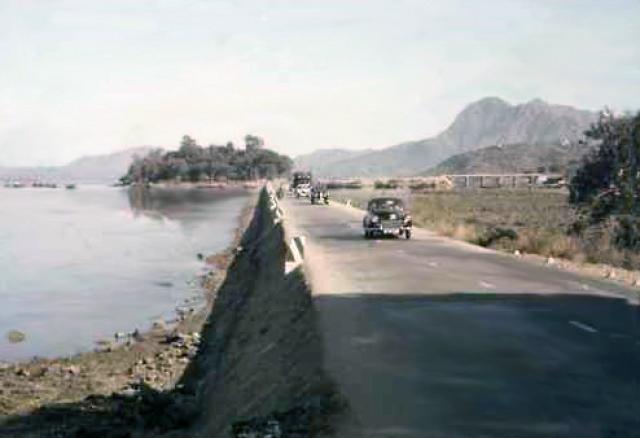
Tai Po Road
Travelled the Sham Shui Po/Shatin/Tai Po road regularly during the 1950's. Any more info on this particular stretch of road and the 'bridge' in the background - and is that a small island on the bend ?
Harry.
Tai Po Rd
Harry
This was the stretch of Tai Po Road that entered into Tai Po Market. The island in the background is Yuen Chau Tsai which still has Island House on it - the former District Officer's residence. During the 60's and 70's it attracted a large population of boat dwellers and a semi-floating slum grew around both sides of the causeway.
In the 80's when Tai Po was redeveloped into a "New Town", both sides of the road were reclaimed extensively. The bridge in the background was just the crossing where the road first passes over the mudflats. Off right would be the level-crossing where the road crosses the railway before heading up towards the hills above Tai Po and towards Shatin.
The modern capture from Google Streetview below shows roughly the same stretch of road.
The road still goes up into the hills at around the same point but now there is a proper road bridge over the railtrack and this stretch of road has now been renamed Kwong Fuk Road. Kwong Fuk estate on the left is the Govt housing estate where many of the former boat-dwellers were moved to when the area was reclaimed.
Tai Po Road
Thanks, Phil, for jogging my memory. I well remember the semi-floating communities developing on each side of the road. The kids on the opposite sides were keen 'kite fliers' doing battle with each other with glass-powdered kite strings. The dog-fight loser's string would drop down - draping itself across the road at head-hight. I caught one across the bridge of my nose when riding my 'bike through there and still have the scar - no full-face helmets in those days
H.